Industry Briefing
A single destination for timely, editor-curated robotics news from around the world.
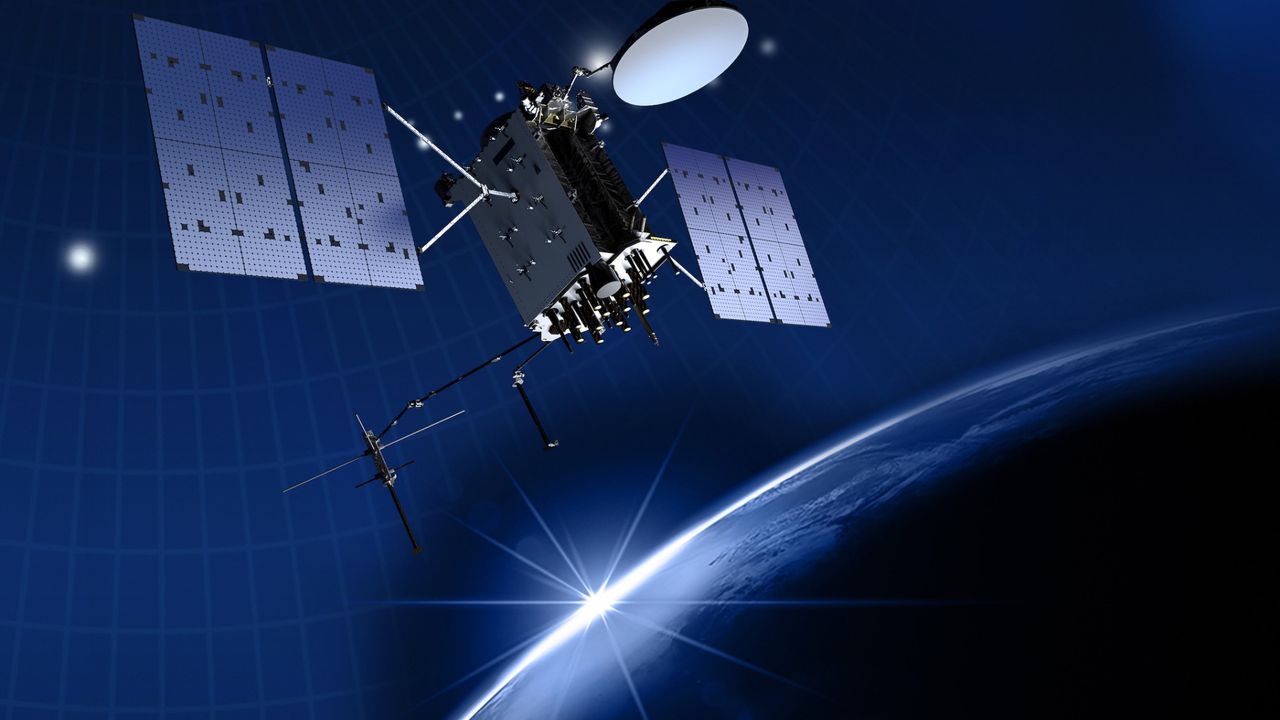
'It's quite a bit more than we expected': Satellite reveals immense scale of GPS signal tampering
An experimental satellite has successfully mapped the extent of GPS jamming across Europe and the Middle East, marking a significant advancement in space-based monitoring technology. This groundbreaking achievement was reported recently, showcasing the satellite's ability to detect and analyze interference in GPS signals from a vantage point in space. The initiative aims to enhance understanding of the growing issue of GPS jamming, which poses risks to navigation and communication systems. By employing advanced sensors and data processing techniques, the satellite collected and transmitted detailed information about the locations and intensity of jamming activities. This development is crucial for improving the resilience of GPS-dependent services and ensuring the reliability of navigation systems in the affected regions.
Satellites Space Exploration
Europe rearms: Battle management, counter-UAS, and real AI at the edge
In a recent initiative aimed at enhancing military capabilities, European defense experts are focusing on the integration of advanced technologies, including drones and artificial intelligence, into modern warfare. This modernization effort is particularly evident in Eastern Europe, where the deployment of drone walls has become a strategic priority. The initiative underscores the growing recognition of the need for innovative solutions to address contemporary security challenges. Taking place throughout 2023, this movement is centered in various Eastern European nations, which are increasingly investing in cutting-edge military technologies to bolster their defense systems. The motivation behind this modernization is driven by the evolving geopolitical landscape and the necessity to respond effectively to potential threats. Experts are collaborating on developing systems that incorporate AI into military vehicles, such as tanks, enhancing their operational efficiency and decision-making capabilities. This integration of technology aims to create a more agile and responsive military force, capable of adapting to rapidly changing combat environments. As Europe navigates these advancements, the emphasis on modernization reflects a broader commitment to maintaining security and stability in the region, ensuring that military forces are equipped to meet future challenges. The ongoing efforts highlight the importance of innovation in defense strategies, positioning European nations at the forefront of military technology development.
Networks & Digital Warfare Sponsored Post artificial intelligence AI Counter UAS cUAS CUAS cyber security
New sub-450-gram mini drone system sustains autonomous surveillance despite GPS jamming
As military forces seek innovative solutions to enhance soldier safety and situational awareness, recent advancements in technology are being explored. These developments aim to provide troops with better protection while ensuring they remain alert to their surroundings. The initiative comes in response to the increasing challenges faced by soldiers operating in high-stress environments, where the balance between safety and awareness is crucial. By integrating cutting-edge wearable devices and advanced communication systems, armies are working to create a more effective and responsive combat experience. This effort is particularly relevant in light of ongoing conflicts and the evolving nature of warfare, which demands that soldiers be both protected and informed. The implementation of these technologies is expected to improve operational efficiency and reduce risks on the battlefield, ultimately enhancing the overall effectiveness of military missions.
Military
DRONELIFE Exclusive Interview: Inside PDW’s Strategy to Build Drones That Can Operate When GPS and Communications Fail
PDW is advancing the development of sophisticated drone communication systems to enhance military operations in environments where traditional communication methods may fail. As global militaries increasingly depend on drones for surveillance and combat, the need for reliable communication links has become critical, especially in areas with contested communication. The company's strategy focuses on creating drones capable of functioning effectively even when GPS and standard communication systems are compromised. This initiative highlights the growing recognition of the importance of resilient drone technology in modern warfare.
Applications Defense defense Drone News Drone News Feeds Dual Use
Taiwan unveils AI drone navigation system that flies through GPS jamming
Taiwan’s Aerospace Industrial Development Corporation (AIDC), a state-backed entity, has introduced an innovative AI-powered navigation system aimed at enhancing the capabilities of its aerospace technology. This announcement was made during a press conference held on October 15, 2023, in Taichung, Taiwan. The new system is designed to improve the safety and efficiency of aircraft operations, reflecting AIDC's commitment to advancing the nation’s aerospace industry amid growing global competition. By integrating artificial intelligence into navigation processes, AIDC aims to streamline flight operations and reduce the risk of human error. The development of this technology comes as part of Taiwan's broader strategy to bolster its defense capabilities and maintain technological sovereignty in the face of regional tensions.

Beyond satellites: Why FOG inertial navigation is the new imperative for land warfare
The landscape of military navigation is undergoing a significant transformation as counterspace threats and electronic warfare challenge the previously uncontested dominance of GPS technology. Exail is at the forefront of this shift, introducing its Fiber Optic Gyro (FOG) technology, which offers enhanced stability and serves as a reliable "source of truth" for land maneuvering and precision targeting in environments where Global Navigation Satellite Systems (GNSS) are compromised. This innovation is crucial for modern military operations, enabling forces to maintain operational effectiveness despite the increasing prevalence of electronic warfare tactics. As the battlefield evolves, Exail’s advancements in navigation technology are poised to play a vital role in ensuring that military units can navigate and execute missions with precision and confidence, even in the most challenging conditions.
Land Warfare Sponsored Post Army autonomy electronic warfare (EW) Exail
How drones can navigate without GPS
In contested and denied environments, the importance of absolute positioning has become increasingly critical. As military operations evolve, forces must rely on precise location data to navigate and execute strategies effectively. This need has been underscored by recent developments in warfare, where traditional navigation methods may be compromised. Experts emphasize that accurate positioning is essential for mission success, particularly in scenarios where GPS signals may be jammed or spoofed. As a result, military organizations are investing in advanced technologies and training programs to enhance their capabilities in these challenging conditions. By integrating innovative solutions, they aim to ensure reliable navigation and operational effectiveness, even in the most complex environments. The ongoing focus on absolute positioning reflects a broader trend in military strategy, where adaptability and technological advancement are paramount. As conflicts continue to evolve, the ability to maintain accurate situational awareness will be crucial for ground forces and their overall mission objectives.
Networks & Digital Warfare Space Sponsored Post anti-drone artificial intelligence AI C4ISR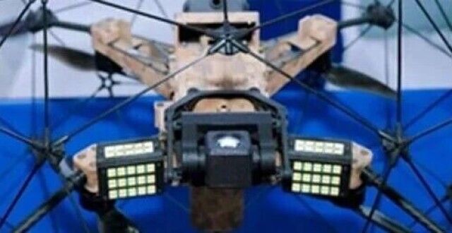
Differential Robotics, a Hangzhou-based flying robot startup, has raised hundreds of millions of RMB in a Series A1 round — bringing its total funding to over 500 million RMB across six rounds in less than two years of operation.
Differential Robotics has successfully secured hundreds of millions in its Series A1 funding round, aimed at scaling the production of its P300 autonomous flying robots. This significant investment comes as the company seeks to enhance the capabilities of its technology for use in complex environments where GPS signals and network connectivity are unreliable or unavailable. The funding will enable Differential Robotics to accelerate development and deployment of its innovative solutions, which are designed to operate effectively in challenging conditions. The announcement marks a pivotal moment for the company, highlighting the growing demand for advanced robotics in various sectors that require autonomous navigation and operation without traditional support systems.
HumanoidRobotics
Terra Drone Deploys Terra A2 Interceptor Drone to Ukraine Frontlines
Terra Drone Corporation, a Japanese drone manufacturer, has officially deployed its Terra A2 interceptor drone to the frontlines in Ukraine. This strategic move, announced on May 19, 2026, is part of a collaborative program with Ukrainian defense technology firm WinnyLab LLC. The introduction of the long-range, wide-area air defense platform aims to enhance Ukraine's defense capabilities amid ongoing conflicts. The operational deployment of the Terra A2 is expected to bolster Ukraine's aerial defense efforts significantly, reflecting the growing international support for the country’s military initiatives.
Anti-drone technology C-UAS Defense Japan Drone Industry Japan Drone News Ukraine Drones
New drone targeting tech counters GPS jamming threats
As GPS jamming and spoofing tactics gain prevalence in modern warfare, drone operators are facing significant challenges with the accuracy of their video feeds. While the visual quality of the footage remains clear, the geographic coordinates associated with it can often be misleading, leading to what defense companies describe as “targeting paralysis.” This phenomenon complicates precision targeting efforts, posing a serious obstacle for military operations. The increasing sophistication of these electronic warfare techniques highlights the urgent need for advancements in drone navigation and targeting systems to ensure operational effectiveness in combat scenarios.
News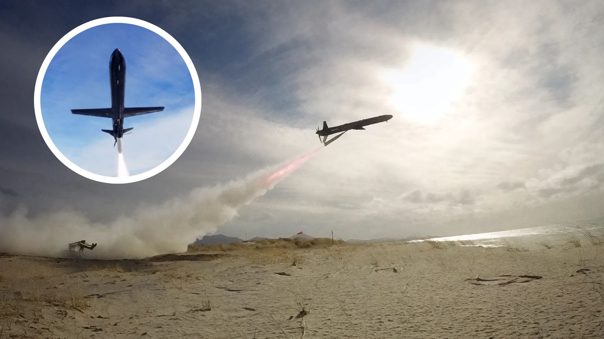
UK tests SkyLance drone built for low-cost strikes in GPS-jammed battlefields
British drone manufacturer Rotron Aerospace has successfully conducted a live firing test of its SkyLance autonomous strike drone. This significant milestone took place recently, showcasing the drone's advanced capabilities in a real-world scenario. The test was held at a designated military testing site in the UK, where the SkyLance demonstrated its precision and effectiveness in targeting. The motivation behind this development is to enhance military operations by providing armed forces with cutting-edge technology that can operate autonomously, thereby reducing risks to personnel. The SkyLance is designed to engage targets with high accuracy, utilizing advanced algorithms and sensor technology to navigate and execute missions independently. This live firing event marks a crucial step in the drone's development, as it allows Rotron Aerospace to gather valuable data on the drone's performance and reliability under combat conditions. The successful test is expected to pave the way for further advancements in autonomous drone technology, potentially transforming modern warfare strategies.

Here is Yarbo’s promise to fix the robot mower that ran me over
A cybersecurity issue has emerged involving Yarbo, a manufacturer of robotic lawn mowers, as reports surfaced of a hacker gaining control of these devices. The incident, which occurred yesterday, highlighted the vulnerability of thousands of these Chinese-made robots, which can be easily hijacked. This breach potentially exposes sensitive information such as GPS coordinates, Wi-Fi passwords, and email addresses to malicious actors. In response to the alarming revelations, Yarbo has issued a statement addressing the security flaws and outlining steps to mitigate the risks associated with their products. The company aims to reassure customers and enhance the safety of their robotic lawn mowers in light of these findings.
News Tech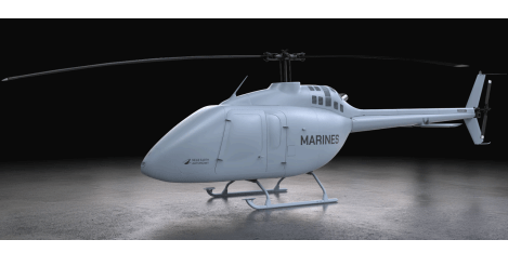
Near Earth Autonomy Wins MARV-EL Contract for Marine Corps Logistics Drone
The Naval Air Systems Command has selected Near Earth Autonomy, a Pittsburgh-based autonomy specialist, to collaborate with Bell Textron, Moog, and XP Services on the development of an uncrewed Bell 505 aircraft. This partnership is part of the Medium Aerial Resupply Vehicle – Expeditionary Logistics (MARV-EL) Increment 2 program, which aims to create a prototype autonomous logistics aircraft for the U.S. Marine Corps. The contract, awarded recently, is intended to enhance the Marine Corps' logistical capabilities by providing a reliable and efficient aerial resupply solution.
AI Drone News Drone News Feeds Logistics News US Government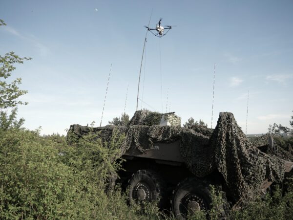
Elistair Khronos Tethered Drone Joins France’s ORION 2026 Exercise
Elistair's Khronos automated tethered drone is participating in ORION 2026, France's largest joint military exercise in decades, which involves 12,500 troops and 1,200 drones. This significant event, aimed at enhancing multi-domain operations, is taking place from April 7 to April 30. The exercise showcases advanced military capabilities, with the automated DroneBox providing continuous aerial surveillance to support the operations. Elistair's involvement highlights the increasing integration of drone technology in modern military strategies.
Drone News Drone News Feeds Europe Drone Industry European Union Military News
Teledyne FLIR Defense Expands Payload Program with Emesent Hovermap for GPS-Denied Operations
Teledyne FLIR Defense has announced an expansion of its Third-Party Payload Integration Program by incorporating Emesent’s Hovermap LiDAR payload, a development unveiled at the Modern Day Marine 2026 event. This integration enables the Hovermap system to function seamlessly across Teledyne FLIR’s unmanned aerial systems (UAS) and ground robots, enhancing capabilities in GPS-denied environments. The collaboration aims to improve operational efficiency and data accuracy in various defense applications, allowing for advanced mapping and radiation detection across both air and ground platforms.
Applications Defense Drone News Drone News Feeds Dual Use LiDAR
Teledyne FLIR Defense Grows Third-Party Payload Integration Program, Adds Emesent Hovermap LiDAR for Unmanned Air, Ground, and Detection Platforms
A newly certified payload is set to enhance the capabilities of drones, robots, and radiation detection systems, facilitating faster deployment of mapping in environments where GPS signals are unavailable. This innovative technology aims to improve the efficiency of fused Chemical, Biological, Radiological, and Nuclear (CBRN) visualizations, which are critical for various applications, including emergency response and environmental monitoring. The certification, achieved in October 2023, underscores the growing importance of advanced technological solutions in navigating complex and hazardous situations. By integrating these systems, operators can obtain real-time data and insights, significantly improving situational awareness and decision-making in challenging scenarios.

Bat-inspired drones could improve search and rescue ops in dark
A researcher at Worcester Polytechnic Institute (WPI) is pioneering innovative drone navigation technology inspired by the echolocation abilities of bats. This development, which aims to enhance the precision and efficiency of drone operations, is particularly relevant in environments where GPS signals are weak or unavailable. The project is currently underway, with the researcher utilizing advanced algorithms to replicate the way bats navigate through complex surroundings. By studying the natural mechanisms of bat echolocation, the team hopes to create drones that can autonomously maneuver in challenging conditions, potentially transforming applications in various fields such as search and rescue, agriculture, and environmental monitoring. This research not only seeks to improve drone functionality but also aims to contribute to the broader understanding of biological navigation systems.
Robotics needs a service framework.
RSF defines a common language for robot service capability, lifecycle operations, certification pathways, and service-provider networks.