Industry Briefing
A single destination for timely, editor-curated robotics news from around the world.
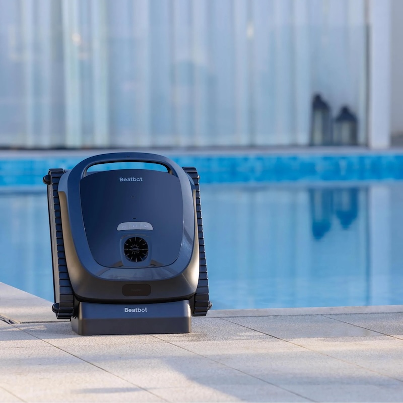
How AI Navigation is Improving the Performance of Robotic Pool Cleaners
Robotic pool cleaners have evolved beyond traditional metrics such as suction power and debris collection, with a significant emphasis now placed on navigation capabilities. Previously, these devices were primarily evaluated based on their ability to pick up dirt and debris, but advancements in technology have shifted the focus to how effectively they can navigate a pool's surface. A robot that operates randomly may clean certain areas thoroughly while neglecting others, leading to inconsistent cleaning results. This change in evaluation criteria reflects a growing understanding that efficient navigation is crucial for maximizing the overall performance of pool cleaning robots. As manufacturers continue to innovate, the integration of sophisticated navigation systems is becoming a key factor in the design and functionality of these devices, ensuring a more comprehensive cleaning experience for pool owners.
Artificial Intelligence Environment Technology AI navigation ai robotics AquaSense 2 Ultra
Underwater robots that are always on call pave the way for pipeline and cable security
As economic activity in ocean spaces continues to rise, there is an increasing demand for regular monitoring and inspection of underwater infrastructure, including pipelines, cables, and installations. This need is driven by the growing complexity of global security concerns, which necessitate enhanced surveillance capabilities. Autonomous underwater vehicles (AUVs) are emerging as vital tools in this effort, offering advanced monitoring solutions that can operate in challenging environments. Furthermore, there is a pressing requirement for greater understanding of the seabed and oceanic regions to support sustainable development and security measures. As stakeholders seek to address these challenges, the integration of AUV technology is expected to play a pivotal role in ensuring the safety and integrity of underwater assets.
Robotics
BRINC Partnership Gives Public Safety Agencies an “Immediate Upgrade” in Incident Intelligence
BRINC, a manufacturer of drones for public safety, has formed a partnership with Nova Software Company to enhance aerial mapping and data analysis for first responders. This collaboration aims to provide public safety agencies with advanced capabilities, enabling them to utilize BRINC drones for improved incident intelligence. The integration of Nova's software will allow these agencies to transform aerial data into actionable insights, significantly upgrading their operational efficiency. This initiative underscores the growing importance of technology in emergency response, as agencies seek innovative solutions to enhance their effectiveness in critical situations. The partnership represents a strategic move to equip first responders with the tools necessary for better decision-making and situational awareness in the field.
Applications Drone News Drone News Feeds emergency response Featured – Safety and Security Fire and Police
New chip could help tiny robots traverse complex environments
A team of researchers has developed an innovative method for creating 3D maps to enhance navigation systems, utilizing a combination of an efficient algorithm and specialized hardware. This advancement, which was announced in October 2023, aims to significantly reduce the memory and power requirements typically associated with 3D mapping technologies. By streamlining the mapping process, the researchers hope to improve the efficiency and accessibility of navigation tools, making them more practical for a variety of applications, including autonomous vehicles and mobile devices. The integration of dedicated hardware with the algorithm allows for rapid map generation, which could lead to faster and more reliable navigation solutions in real-world scenarios.
Research Computer science and technology Algorithms Artificial intelligence Machine learning Robotics
SPH Engineering and Vets to Drones Partner to Expand Career Paths for Military Veterans
SPH Engineering has launched a new training initiative in collaboration with Vets to Drones, aimed at equipping military veterans with advanced flight planning skills essential for surveying, mapping, and inspection work in the commercial drone industry. This partnership responds to the growing demand for skilled drone operators capable of managing complex missions. By providing veterans with specialized training, the initiative seeks to expand their career opportunities in a rapidly evolving field. The program highlights the commitment of both organizations to support veterans in transitioning to civilian roles while addressing the industry's workforce needs.
Applications Drone News Drone News Feeds Drones in the News Mapping News
A Review on Search and Rescue Robots in Complex Scenarios: Key Technologies of Simultaneous Localisation and Mapping
A recent study published in the Journal of Field Robotics highlights the advancements in autonomous robotic systems designed for agricultural applications. Researchers from various institutions collaborated to explore innovative technologies that enhance efficiency and sustainability in farming practices. The findings, released in early October 2023, emphasize the growing need for automation in agriculture to address labor shortages and improve crop yields. The research team conducted extensive field tests to evaluate the performance of these robotic systems in real-world farming scenarios. By integrating artificial intelligence and machine learning, the robots demonstrated the ability to perform tasks such as planting, monitoring, and harvesting with remarkable precision. This technological progress aims to support farmers in overcoming challenges posed by climate change and increasing food demand. The study underscores the importance of developing reliable and cost-effective robotic solutions that can be easily adopted by farmers. As the agricultural sector faces mounting pressures, the implementation of these advanced technologies could significantly transform traditional farming methods, leading to more sustainable practices and enhanced productivity.
SURVEY ARTICLE
RTK Data Coverage Explained: Why Access to Many RTK Stations Matters
Accurate field positioning relies not only on high-quality GNSS receivers but also on the effectiveness of the correction networks that support them. Factors such as the distance from correction stations, signal quality, system uptime, and regional availability play crucial roles in determining the stability of the final positioning results. Field teams can achieve enhanced RTK precision by utilizing RTKdata as a provider, which offers extensive access to a robust network of correction services. This integration ensures that teams can maintain strong positioning accuracy in various operational environments.
Communications Technology automation news construction technology drone mapping gnss
Heavy‐UUV Docking System for a Fixed Seabed Station Based on Differential Optical‐Guidance Beacons
The Journal of Field Robotics has recently published an early view article highlighting advancements in robotic technology. Researchers from various institutions have collaborated to develop a new autonomous navigation system that enhances the efficiency and safety of field operations. This innovative system was tested in agricultural settings in California during the summer of 2023, where it demonstrated significant improvements in crop monitoring and resource management. The motivation behind this research stems from the growing need for precision agriculture, which aims to optimize farming practices and reduce environmental impact. By integrating advanced sensors and machine learning algorithms, the team was able to create a robotic platform capable of navigating complex terrains while collecting valuable data on soil health and crop conditions. The successful implementation of this technology could revolutionize the agricultural sector, providing farmers with tools to make informed decisions and increase productivity. The findings are expected to contribute to ongoing discussions about sustainable farming practices and the role of robotics in addressing global food security challenges.
RESEARCH ARTICLE
Japan Agriculture Drone Market Projected to Reach $357.8M by 2034
A recent report from the Tokyo-based Market Research Center, in collaboration with the Japan UAS Industrial Development Association (JUIDA), projects that Japan's agriculture drone market will reach $357.8 million by 2034. The report estimates the market's value at $104.8 million in 2025 and anticipates a compound annual growth rate (CAGR) of 14.62% over the next decade. This growth is driven by increasing demand for advanced agricultural technologies aimed at enhancing efficiency and productivity in farming practices. The findings highlight the significant potential for drones to transform the agricultural landscape in Japan, reflecting a broader trend towards innovation in the sector.
Agriculture Drone News Drone News Feeds Farming Drones Featured - Agriculture Japan Drone Industry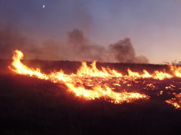
Landair Surveys Uses SimActive Correlator3D for Planned Burns Mapping in Australia
Landair Surveys, an Australian geospatial firm, is utilizing SimActive's Correlator3D software to create orthomosaics from aerial imagery. This initiative is part of their efforts in wildfire prevention and land management, specifically for planned burns mapping projects across Australia. The Montreal-based software developer announced this collaboration, highlighting that the workflow aims to enhance the efficiency of geospatial outputs. The use of advanced aerial imagery technology is expected to improve land management strategies and contribute to effective wildfire prevention measures.
Digital Twins Disaster Response Drone News Drone News Feeds Fire Firefighter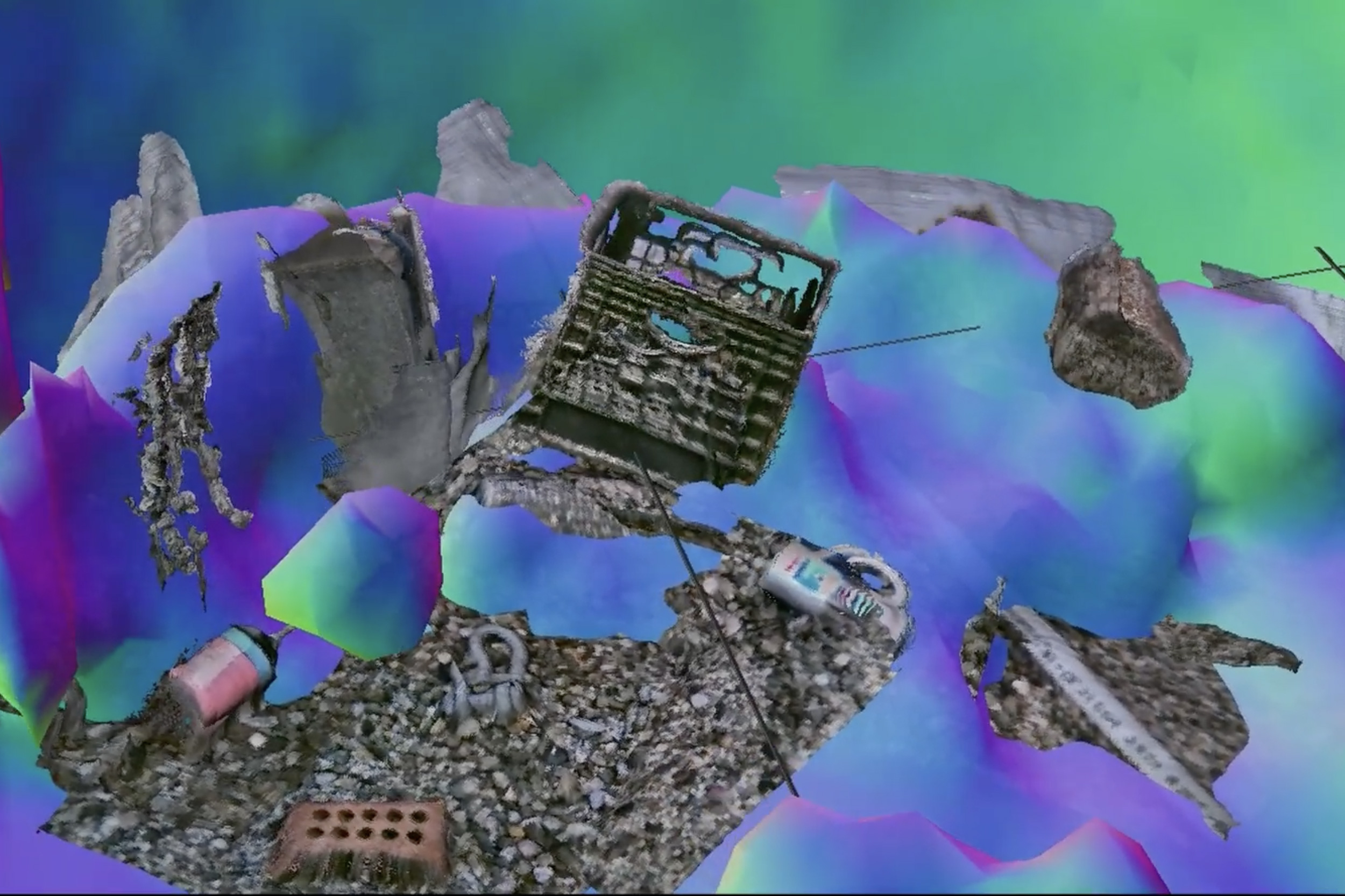
New imaging system sees through murky waters
A groundbreaking technology known as “Sonar-MASt3R” has been developed to enhance underwater mapping capabilities by integrating sonar and visual data. This innovative system is capable of producing real-time 3D maps, significantly improving navigation and exploration in challenging environments, including cloudy water conditions. The technology was unveiled in October 2023, showcasing its potential to revolutionize marine research and underwater operations. By combining different data sources, Sonar-MASt3R addresses the limitations of traditional mapping methods, offering clearer and more accurate representations of underwater landscapes. This advancement is expected to benefit various sectors, including environmental monitoring, maritime safety, and underwater archaeology, by providing researchers and professionals with reliable tools for better decision-making in aquatic environments.
Research Robotics Computer vision Imaging Sensors Oceanography and ocean engineering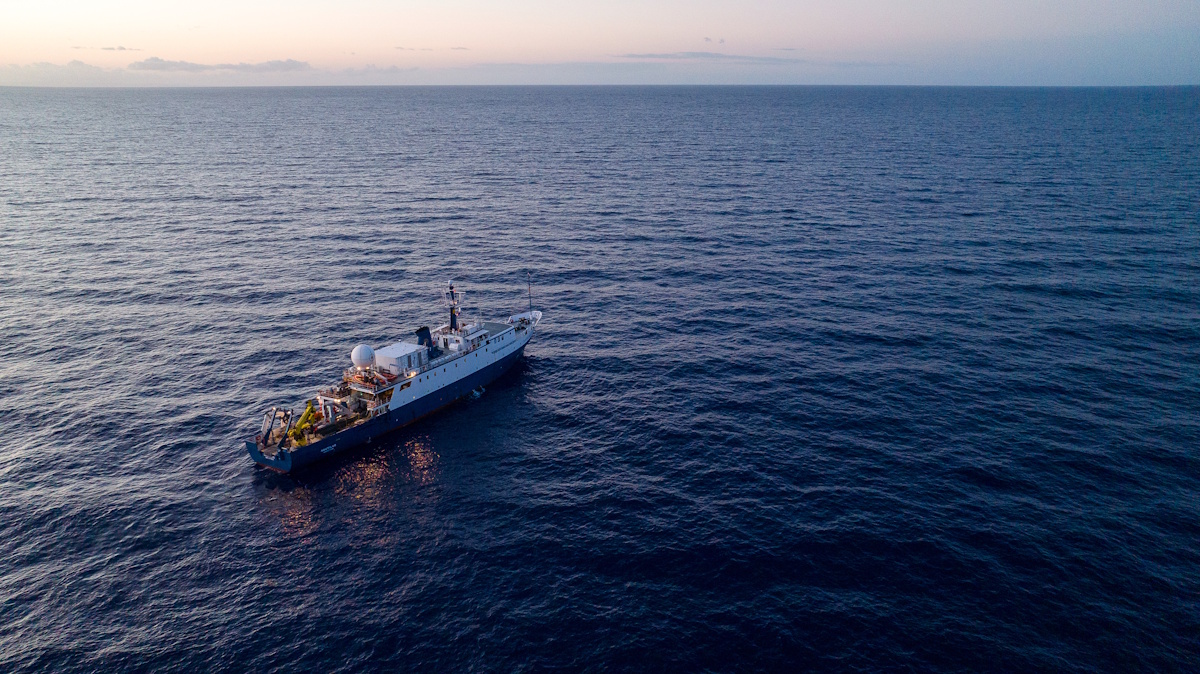
Ocean Exploration Trust Launches Expedition with New Mapping Sonar to Explore Deeper than Ever!
The Ocean Exploration Trust (OET) launched its Exploration Vessel (E/V) Nautilus today for the inaugural expedition of 2026, marking a significant advancement in deep-sea exploration. This expedition, named Pacific Mapping (NA178), features the first operational deployment of the newly installed Kongsberg EM 304 MKII multibeam sonar technology, which enhances the vessel's capability to explore ocean depths more effectively than ever before. The initiative aims to expand our understanding of the Pacific Ocean's underwater landscapes and ecosystems, leveraging cutting-edge technology to gather critical data. The expedition underscores OET's commitment to marine research and exploration, as it seeks to uncover the mysteries of the ocean and contribute to scientific knowledge.
ocean exploration trust’s (oet) e/v nautilus expedition 2026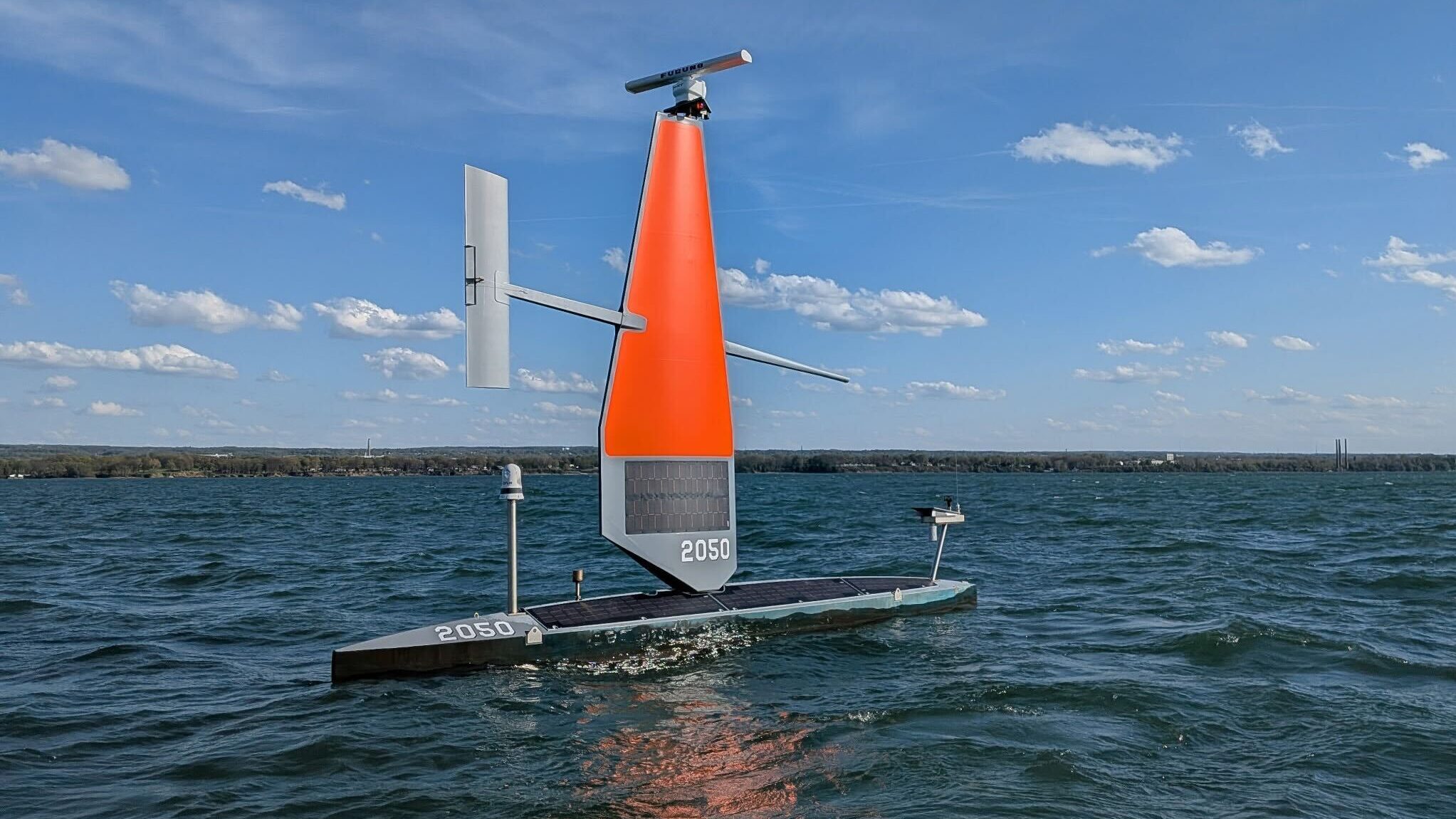
Coast Guard, Saildrone team up in northern waters to boost border security, surveillance
The Voyager, a state-of-the-art surveillance vessel, has been designed to carry out continuous coastal monitoring and nearshore mapping operations. This advanced ship can remain deployed at sea for approximately 100 days, enhancing its capability to gather critical data over extended periods. The implementation of the Voyager is expected to significantly improve maritime security and environmental monitoring efforts, providing valuable insights into coastal ecosystems and aiding in the management of marine resources. With its advanced technology and extended operational range, the Voyager represents a significant advancement in maritime surveillance capabilities.
Naval Warfare border security coast guard Drones Navy Saildrone
Beyond Dexterity: Why Contact May Define the Next Era of Robotics
At the 2026 IEEE International Conference on Robotics (ICRA) in Vienna, AGILINK showcased a captivating demonstration of robotic dexterity by creating a balloon dog, which drew significant attention from attendees. This seemingly playful task is recognized in the robotics community as a complex manipulation challenge due to the balloon's lightweight and highly deformable nature. The demonstration highlighted the intricate balance between motion and contact intelligence, essential for successful robotic manipulation. AGILINK's approach involved mapping the actions of professional balloon artists to robotic hands, allowing the robot to learn both successful manipulation sequences and recovery strategies during failures. This dual focus on motion and contact intelligence is crucial, as maintaining stable interaction with the balloon is as important as executing the correct sequence of actions. In conjunction with the balloon dog demonstration, AGILINK introduced the OmniHand 3 Ultra-M, a dexterous robotic hand designed to enhance contact intelligence through advanced sensing and faster response capabilities. The hand features 20 active degrees of freedom and a direct-drive architecture, enabling precise force regulation and tactile sensing across its surface. The significance of these advancements extends beyond balloon animals, addressing broader challenges in robotics related to unstable and deformable interactions, such as delicate assembly and household tasks. As robotics research increasingly prioritizes interaction dynamics, AGILINK's innovations may pave the way for more effective manipulation in unpredictable real-world environments.
Humanoid-robots Physical-ai Dexterous-hands Direct-drive-actuation Robotic-manipulation Reinforcement-learning
Robots move beyond mapped worlds with advanced lidar sensing
A lidar technology company has partnered with a robotics AI developer to enhance the capabilities of autonomous systems. This collaboration, announced recently, aims to integrate advanced lidar sensing with cutting-edge artificial intelligence to improve navigation and object recognition in various applications, including autonomous vehicles and drones. The partnership is expected to leverage the strengths of both companies, combining precise environmental mapping with intelligent decision-making algorithms. This initiative comes in response to the growing demand for more reliable and efficient autonomous solutions in industries such as transportation and logistics. The companies plan to begin testing their integrated systems in the coming months, with the goal of launching a prototype by early next year.

Japan to develop deep-sea drone in hunt for rare earths
A Japanese marine research agency is set to develop an advanced autonomous underwater vehicle (AUV) by fiscal 2028 to enhance the search for rare earth elements and other mineral resources in the seabed near Minamitorishima, Japan's easternmost territory. This initiative, announced on June 3, 2026, aims to secure a stable supply of these critical materials, which are essential for various high-tech industries. The project reflects Japan's ongoing efforts to reduce its dependence on foreign sources, particularly China, amid rising global demand for rare earths. The development of this hybrid vessel is expected to significantly accelerate exploration and retrieval processes in the region, positioning Japan as a key player in the global rare earth supply chain.

SkyeBrowse makes every photo inside a drone 3D model clickable
SkyeBrowse has announced a significant update to its drone mapping software aimed at enhancing user experience in interpreting 3D models. The update, which is now available to all users at no extra charge, focuses on improving model quality and advancing AI-generated floor plans. Additionally, the newly accessible Image Walkthroughs feature is designed to assist users in better understanding the data captured through drone technology. This update addresses a common challenge faced by users in navigating and analyzing complex 3D representations, thereby streamlining the process of extracting valuable insights from aerial imagery.
News
SMILE-FX Launches AI Braces System, Bringing Predictive Treatment Planning to South Florida
Dr. Tracy M. Liang, a board-certified orthodontist, has unveiled a groundbreaking orthodontic treatment at SMILE-FX Orthodontic Studio in Miramar, Florida. On April 3, 2026, the clinic launched its AI Braces system, which uniquely combines artificial intelligence with advanced 3D CBCT (Cone Beam Computed Tomography) imaging. This innovative approach aims to enhance the precision and effectiveness of orthodontic treatments by providing detailed, data-informed mapping for each patient's needs. The integration of cutting-edge technology is designed to improve patient outcomes and streamline the orthodontic process, reflecting a significant advancement in the field.
Design Health 3D CBCT imaging 3d printing AI braces AI diagnostics
Niantic Spatial and Spexi Turn Drone Imagery Into Physical AI
Niantic Spatial and Spexi Geospatial have formed a strategic partnership to enhance the use of aerial drone imagery for enterprise applications. This collaboration integrates Spexi’s extensive aerial data network with Niantic Spatial’s advanced 3D reconstruction technology, enabling the creation of city-scale 3D Gaussian splats. Announced recently, this initiative aims to provide businesses with on-demand access to drone imagery, facilitating the development of physical AI solutions. The partnership is expected to streamline the process of transforming aerial captures into actionable data for various industries, marking a significant advancement in the utilization of drone technology for commercial purposes.
AI Drone News Drone News Feeds Mapping News 3D reconstruction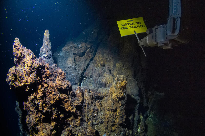
Greenpeace robot stages deepest-ever seabed protest
In a groundbreaking initiative, Greenpeace has launched an underwater robot to conduct a scientific survey of vulnerable deep-sea ecosystems along the Arctic Mid-Ocean Ridge. This event marks the deepest banner protest ever executed from the seabed, occurring at a depth of 2,300 meters. The robot displayed a powerful message urging global leaders to heed scientific advice, stating, “LISTEN TO THE SCIENCE!” The campaign aims to raise awareness about the urgent need for action to protect these unexplored marine environments. Dr. Sandra Schöttner, a key figure in the initiative, emphasized the importance of scientific research in informing policy decisions regarding environmental conservation. This innovative protest not only highlights the threats facing deep-sea ecosystems but also seeks to galvanize international attention and action on climate change and marine protection.
Environment News Arctic Ocean automation news autonomous underwater vehicles climate change
Report: Chinese Suppliers Embedded in U.S. Space Sector
Altana has revealed a significant infiltration of Chinese and Russian suppliers within the U.S. industrial space supply chain. This finding highlights the growing concern regarding foreign influence and potential security risks in critical sectors. The analysis, conducted recently, underscores the need for heightened scrutiny and regulatory measures to safeguard American interests. By mapping the supply chain, Altana aims to inform policymakers and industry leaders about the vulnerabilities posed by these foreign entities, prompting discussions on how to mitigate risks and ensure the integrity of the supply chain.
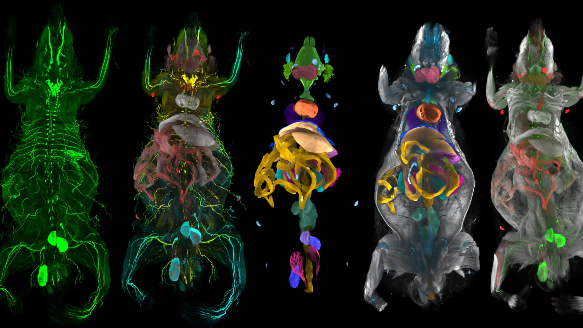
New AI body map reveals obesity’s hidden attack on facial nerves
A team of scientists has developed an advanced AI-powered system capable of scanning and mapping the entire body of a mouse with remarkable precision. This innovative technology has revealed unexpected findings regarding the effects of obesity. In addition to its well-known impact on metabolism, the research indicates that obesity may also harm facial sensory nerves associated with touch and sensation. Furthermore, the study highlights that obesity triggers extensive inflammation throughout the body. These discoveries contribute to a deeper understanding of the health implications of obesity and underscore the potential of AI in biomedical research.
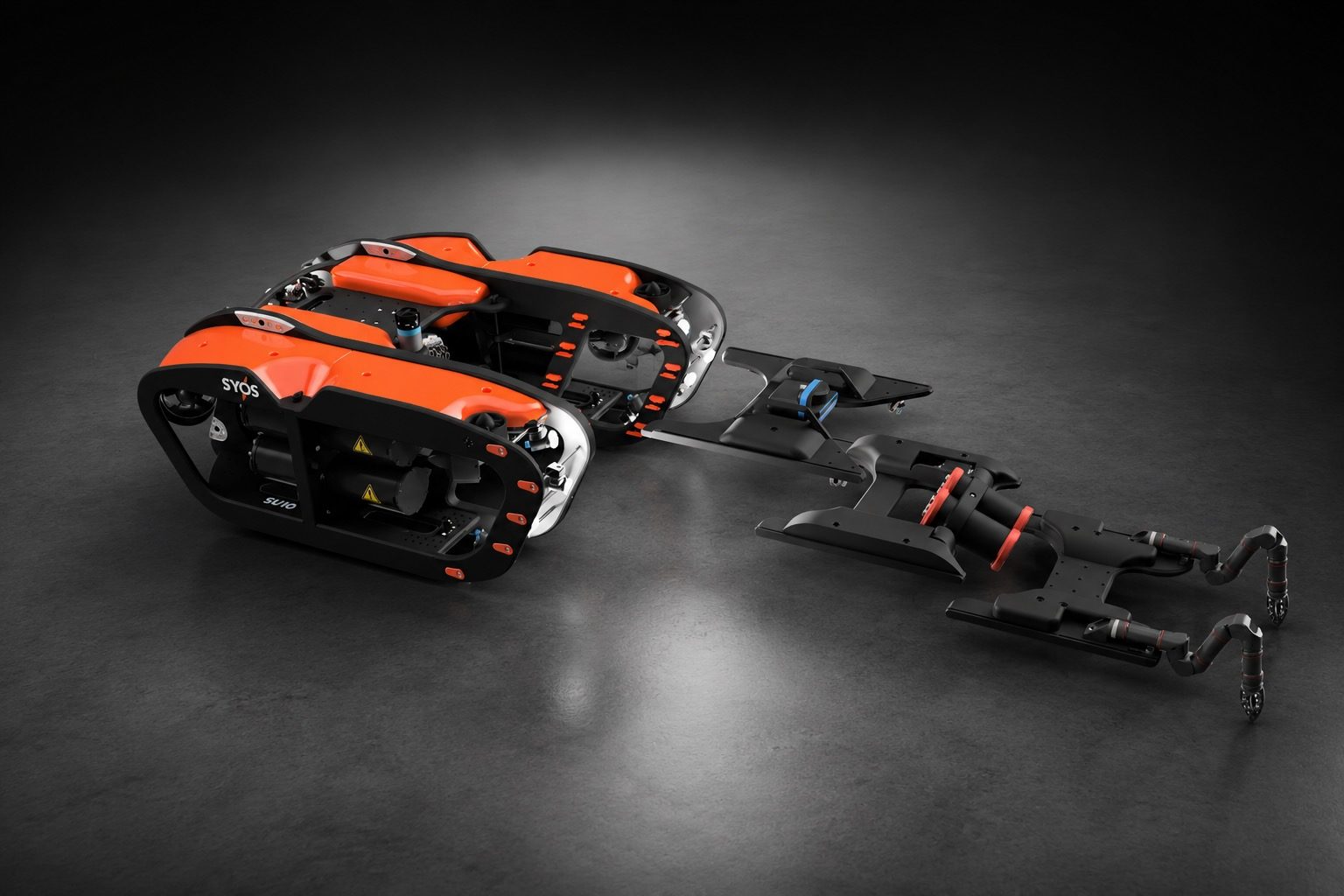
Under the Ice: New SYOS Underwater Drone Targets Maritime Security and Antarctic Exploration
SYOS, an autonomous systems company based in the UK and New Zealand, has unveiled its latest innovation, the SU10 uncrewed underwater vehicle (UUV), aimed at enhancing maritime security and supporting Antarctic exploration. The announcement was made during a recent event, marking a significant expansion of SYOS's portfolio, which previously focused on air and land operations. The introduction of the SU10 allows the company to venture into subsurface missions, addressing the growing demand for advanced technologies in multi-domain operations. This new underwater drone is designed to operate effectively in challenging environments, underscoring SYOS's commitment to developing versatile solutions for both security and exploration purposes.
Applications Arctic Drone News Drone News Feeds Dual Use News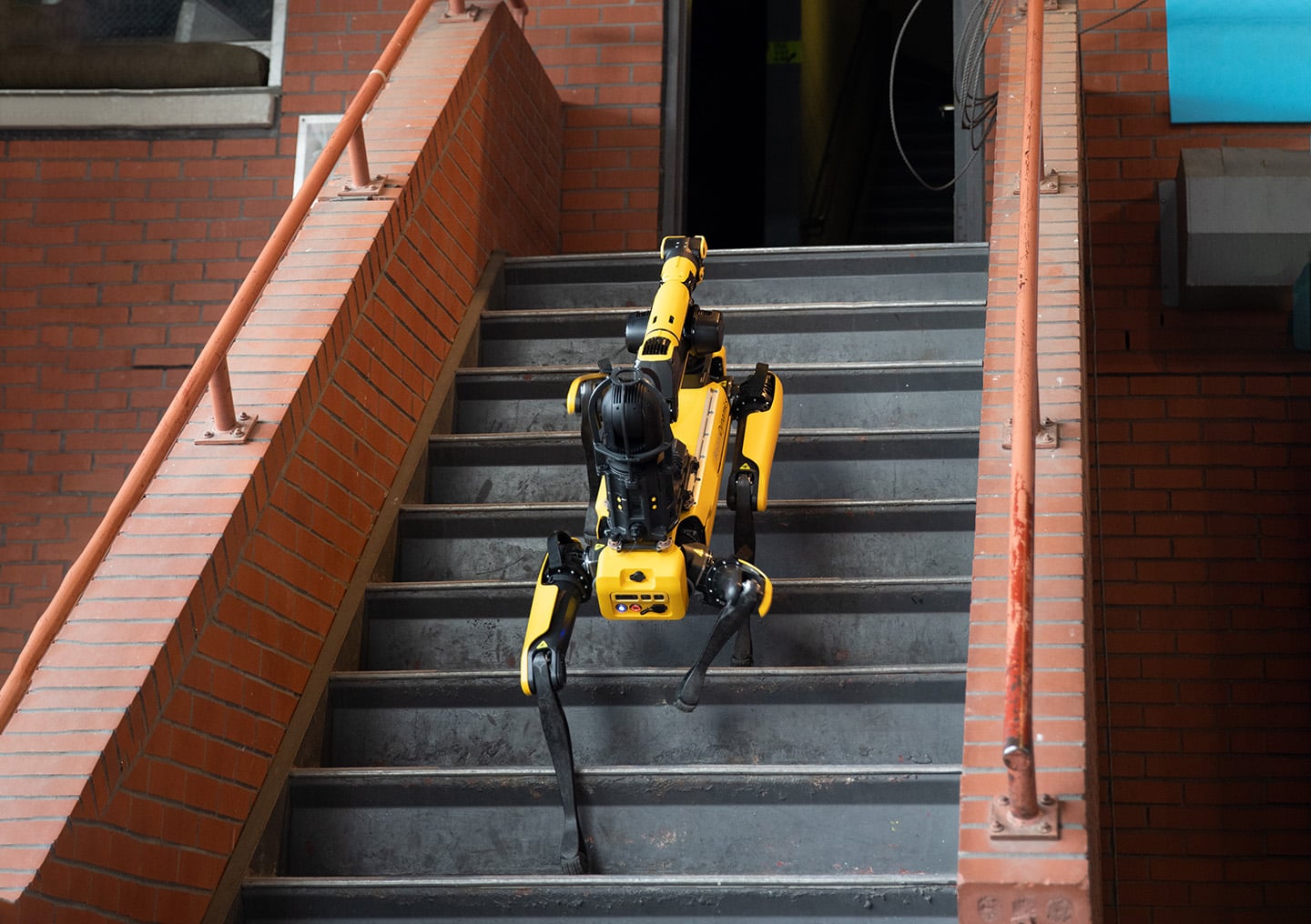
Giving First Responders an Advantage with Autowalk | Boston Dynamics
Public safety agencies are increasingly utilizing Spot, an advanced robotic technology, to enhance their emergency response strategies. By mapping out facilities prior to potential crises, these agencies aim to provide responding teams with critical information and a strategic advantage during emergencies. This proactive approach allows for better preparedness and more efficient management of incidents, ultimately improving safety outcomes. The implementation of Spot's mapping capabilities is expected to streamline operations and facilitate quicker decision-making when emergencies arise.
How agentic AI can enable general-purpose robotic navigation
Researchers are exploring the capabilities of agentic AI to enhance robotic navigation by integrating perception, simultaneous localization and mapping (SLAM), reasoning, and planning. This innovative approach aims to improve the performance of robots operating in dynamic environments. The findings were discussed in a recent article published by The Robot Report, highlighting the potential of agentic AI to transform how robots navigate and interact with their surroundings. By leveraging advanced algorithms and technologies, this method seeks to address the challenges faced by robots in real-world scenarios, ultimately paving the way for more versatile and efficient robotic systems.
Artificial Intelligence Artificial Intelligence / Cognition Autonomous Mobile Robots (AMRs) Cameras / Imaging / Vision Mobility / Navigation Motion Control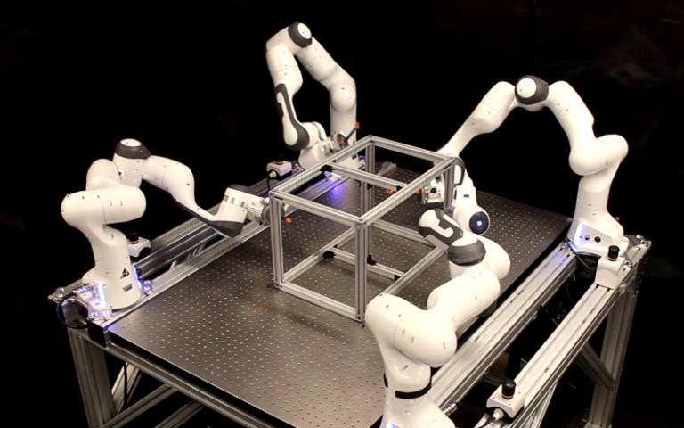
Autonomous seeking and mapping coral reef biodiversity hotspots with a multimodal AUV
In a groundbreaking study published in the May 2026 issue of Science Robotics, researchers have unveiled a new robotic system designed to assist in complex surgical procedures. This innovative technology, developed by a team of engineers and medical professionals, aims to enhance precision and reduce recovery times for patients undergoing surgery. The research was conducted at a leading medical institution, where the team tested the robotic system in a series of simulated surgeries. The results demonstrated significant improvements in accuracy compared to traditional surgical methods, showcasing the potential for robots to play a crucial role in the operating room. The motivation behind this development stems from the increasing demand for minimally invasive surgical techniques that can lead to quicker patient recovery and lower risk of complications. By integrating advanced robotics with surgical practices, the team hopes to address these challenges and improve overall patient outcomes. The robotic system operates through a combination of artificial intelligence and real-time data analysis, allowing it to adapt to the unique requirements of each surgical procedure. This adaptability is expected to empower surgeons, providing them with enhanced tools to perform intricate tasks with greater confidence. As the medical community continues to explore the integration of robotics in healthcare, this study represents a significant step forward in the evolution of surgical practices, potentially transforming the landscape of modern medicine.
Research Article
BM3D‐Based Optical Flow Tracking for Enhanced Visual Simultaneous Localization and Mapping Systems in Mobile Robotics
The Journal of Field Robotics has recently published an early view article highlighting advancements in robotic technology. This publication, released in October 2023, showcases innovative research that aims to enhance the capabilities of field robots in various applications, including agriculture, search and rescue, and environmental monitoring. The research is driven by the growing need for automation and efficiency in these sectors, as well as the increasing complexity of tasks that robots are expected to perform. The findings suggest that integrating advanced algorithms and machine learning techniques can significantly improve the performance and adaptability of robotic systems in real-world scenarios. This research not only contributes to the academic field but also has practical implications for industries looking to leverage robotics for improved operational efficiency and safety.
RESEARCH ARTICLE
Gaussian Splatting Meets Photogrammetry: SimActive Integrates New Capability in Correlator3D
Gaussian splatting, a cutting-edge technique in 3D reconstruction, has gained significant attention for its ability to produce highly realistic and smooth-rendered scenes. This development has prompted discussions within the geospatial industry regarding its potential to extend beyond mere visualization and enhance real-world mapping workflows. In response to this growing interest, SimActive has integrated Gaussian splatting capabilities into its Correlator3D software. This integration aims to leverage the advantages of the technique to improve photogrammetry processes, thereby facilitating more accurate and efficient mapping solutions. The announcement highlights the ongoing evolution of technology in the geospatial field and its implications for practical applications.
Applications Canada Canadian Drone Industry DL Exclusive Drone News Drone News Feeds
TMC and Allseas Sign Commercial Agreement for the First Offshore Nodule Recovery Operation
TMC the metals company Inc., a prominent developer of critical metals vital for energy, defense, manufacturing, and infrastructure, has signed a significant contract with Allseas. This agreement focuses on the development, commissioning, and operation of the first commercial nodule collection system. The collaboration aims to prepare for nodule recovery operations in the Clarion Clipperton Zone of the Pacific Ocean. This initiative marks a crucial step in advancing the extraction of essential resources from the seabed, highlighting the growing importance of deep-sea mining in meeting global demands for critical metals.
tmc allseas commercial agreement offshore nodule recovery operation
Titan Batteries Opens European Drone Battery Plant in Tilburg
Titan Batteries, a drone battery manufacturer based in Pocatello, Idaho, has made a significant move in the industry by launching its first full-scale production facility in Europe. The new plant, located in Tilburg, Netherlands, was officially opened on May 2, 2026, coinciding with International Drone Day. This expansion marks Titan Batteries as the first major drone battery maker to operate production on two continents, reflecting the company’s commitment to meeting the growing demand for UAV power solutions. The Tilburg facility is situated on the Energy Conversion Campus, positioning Titan to leverage advanced technologies and resources in the region.
battery technology Drone News Drone News Feeds European Union News Bosch
US Army Corps of Engineers Awards Fugro Five‑year Contract for Critical Infrastructure Mapping
Fugro has been awarded a five-year indefinite-delivery, indefinite-quantity (IDIQ) contract by the US Army Corps of Engineers (USACE) to deliver surveying and mapping services. This contract, which supports both civil works and military infrastructure programs, will be effective immediately and will cover projects across the United States and internationally. The initiative aims to enhance USACE’s management of essential waterways, flood-risk systems, and military facilities. By providing timely and high-quality geospatial data, Fugro will play a crucial role in informing infrastructure planning, risk management, and operational readiness in various complex and demanding environments.

Teledyne FLIR adds Emesent Hovermap to third-party payload programme
Teledyne FLIR Defense has announced the certification of Emesent’s Hovermap LiDAR payload for integration with its uncrewed aerial systems (UAS), ground robots, and radiation detection platforms. This development, which took place in October 2023, enhances the capabilities of Teledyne FLIR's technology by allowing for advanced mapping and navigation in various environments. The certification aims to improve operational efficiency and data collection accuracy in defense and industrial applications. By incorporating the Hovermap LiDAR payload, Teledyne FLIR Defense is positioned to offer more robust solutions for complex missions, leveraging Emesent's innovative technology to enhance situational awareness and safety.
News
Beacon Biosignals is mapping the brain during sleep
Jake Donoghue, a PhD graduate from MIT, and former MIT researcher Jarrett Revels have launched a company focused on developing an AI-driven platform aimed at diagnosing and treating diseases. This innovative initiative seeks to leverage advanced artificial intelligence technologies to enhance medical decision-making and improve patient outcomes. The platform is currently in development, with the founders drawing on their extensive research backgrounds to create a solution that addresses critical challenges in healthcare. By integrating AI into the diagnostic process, the company aims to streamline the identification of diseases and facilitate more effective treatment plans. The project reflects a growing trend in the medical field, where technology is increasingly being utilized to augment traditional healthcare practices.
Startups Alumni/ae Alzheimer's Parkinson's Disease Neuroscience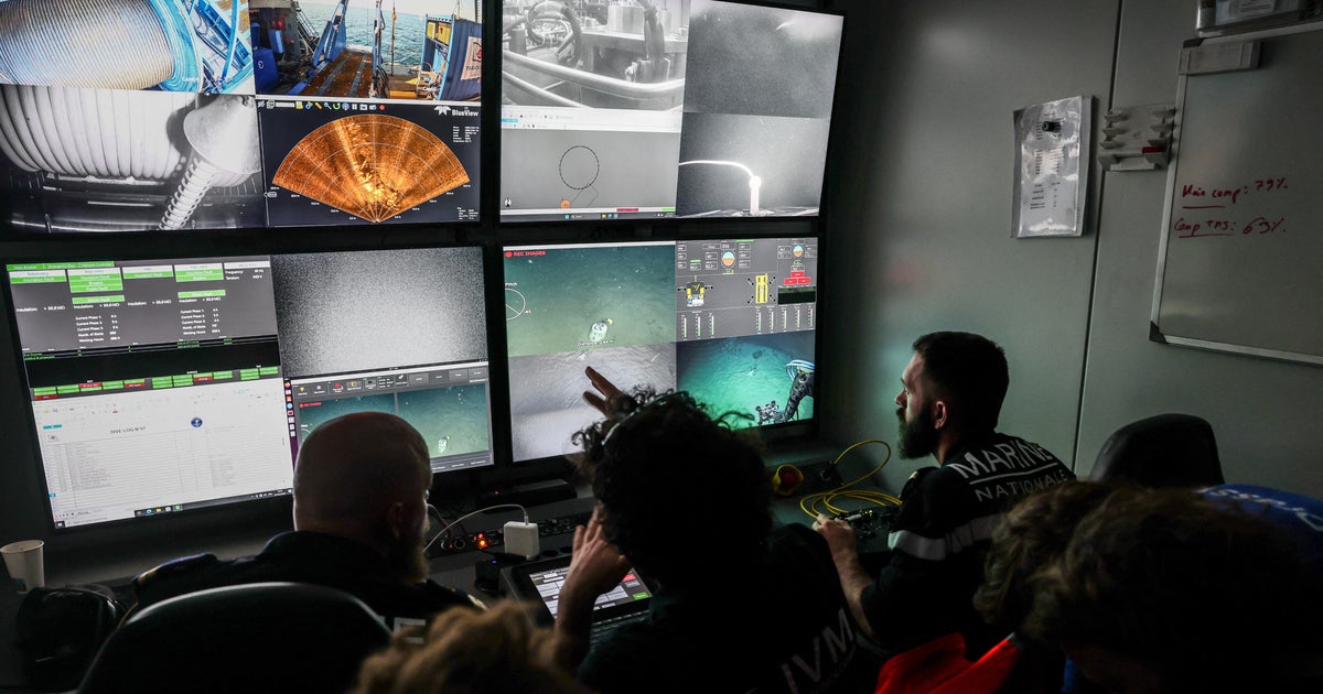
Robot exploring France's deepest shipwreck finds cannons, ceramics
A recent survey conducted by the French army has led to the unexpected discovery of a 16th-century merchant ship in the waters off the coast of France. The find occurred during routine seabed examinations, highlighting the potential for uncovering historical artifacts beneath the ocean's surface. This significant archaeological discovery sheds light on maritime trade practices of the era and contributes to the understanding of France's naval history. The ship's condition and contents are yet to be fully assessed, but experts are optimistic about the insights it may provide into the past. The discovery underscores the importance of ongoing marine exploration and the historical treasures that may still lie hidden beneath the waves.
Teledyne FLIR Defense Expands Payload Program with Emesent Hovermap for GPS-Denied Operations
Teledyne FLIR Defense has announced an expansion of its Third-Party Payload Integration Program by incorporating Emesent’s Hovermap LiDAR payload, a development unveiled at the Modern Day Marine 2026 event. This integration enables the Hovermap system to function seamlessly across Teledyne FLIR’s unmanned aerial systems (UAS) and ground robots, enhancing capabilities in GPS-denied environments. The collaboration aims to improve operational efficiency and data accuracy in various defense applications, allowing for advanced mapping and radiation detection across both air and ground platforms.
Applications Defense Drone News Drone News Feeds Dual Use LiDAR
Teledyne FLIR Defense Grows Third-Party Payload Integration Program, Adds Emesent Hovermap LiDAR for Unmanned Air, Ground, and Detection Platforms
A newly certified payload is set to enhance the capabilities of drones, robots, and radiation detection systems, facilitating faster deployment of mapping in environments where GPS signals are unavailable. This innovative technology aims to improve the efficiency of fused Chemical, Biological, Radiological, and Nuclear (CBRN) visualizations, which are critical for various applications, including emergency response and environmental monitoring. The certification, achieved in October 2023, underscores the growing importance of advanced technological solutions in navigating complex and hazardous situations. By integrating these systems, operators can obtain real-time data and insights, significantly improving situational awareness and decision-making in challenging scenarios.

Deepvein Mining Tech Wins NY Product Design Gold for Exploration Robotics
Deepvein Mining Tech has been awarded Gold at the 2026 NY Product Design Awards for its innovative series of Intelligent Geological Mapping and Geochemical Sampling Quadrupedal Robots. This recognition highlights the company's advancements in robotic systems specifically designed for mineral exploration in challenging and remote environments. The award underscores the importance of technology in enhancing safety and efficiency in high-risk mining operations.
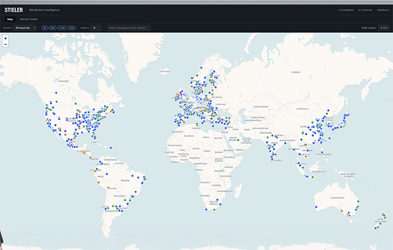
Report finds that while 500k+ robots were installed last year, partner layer is still hard to map
A recent report highlights the challenges in identifying integrator partners within the robotics industry, despite the clear identification of leading vendors and regions. Georg Stieler, a key figure in the analysis, noted that while over 500,000 robots were installed globally last year, the complexity of mapping the partner layer remains a significant hurdle. This underscores the evolving landscape of robotics, where collaboration between manufacturers and integrators is crucial for advancing technology and market penetration. The findings emphasize the need for improved strategies to navigate the intricate network of partnerships that support the robotics sector's growth.
Analysis Assembly Automotive China Collaborative Robots Industrial Robots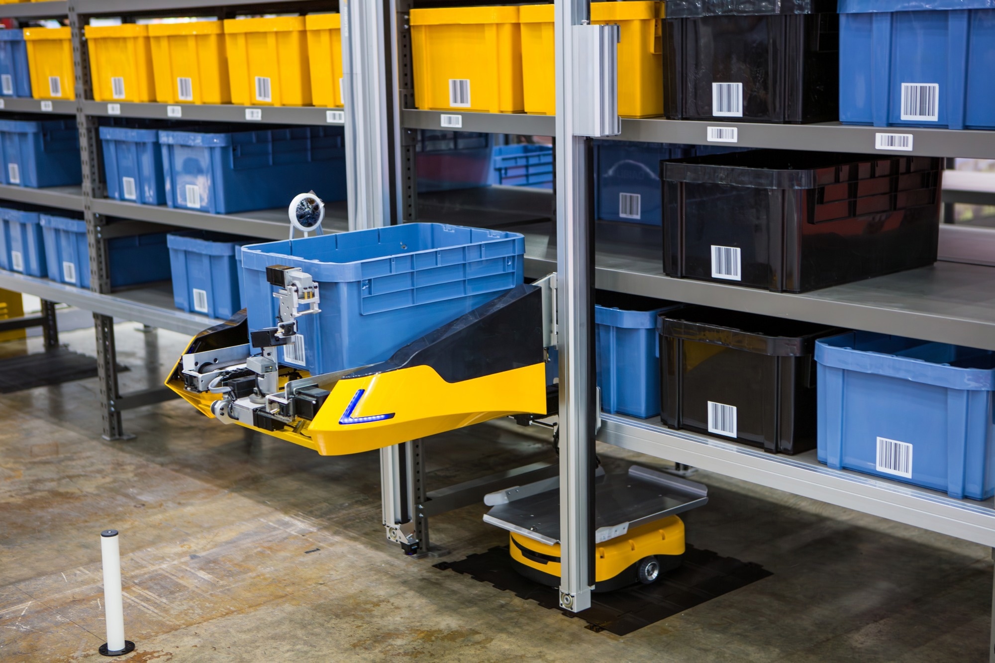
VSLAM Navigation Improves Indoor Logistics Robot Efficiency
A new research initiative has unveiled a VSLAM (Visual Simultaneous Localization and Mapping) framework designed to enhance obstacle avoidance in indoor logistics. This innovative approach utilizes advanced algorithms and integrates multiple sensors to improve navigation efficiency within complex environments. Conducted by a team of researchers, the study aims to address the growing challenges faced in warehouse and distribution center operations. By optimizing the movement of automated systems, the framework seeks to minimize accidents and increase productivity. The findings, which were developed using data collected up to October 2023, promise to significantly advance the capabilities of indoor logistics technology.

Amap debuts quadruped robot Tutu at Beijing humanoid half-marathon
Amap, the mapping platform under Alibaba, introduced its innovative quadruped robot named Tutu during the 2026 Beijing E-Town Humanoid Robot Half-Marathon. This event showcased Tutu's capabilities in assisting visually impaired individuals by navigating complex environments autonomously, without the need for preset routes or remote control. Demonstrations at the marathon highlighted the robot's ability to maneuver through crowds and avoid obstacles effectively. Amap aims to enhance mobility and independence for visually impaired users with this advanced technology, marking a significant step forward in assistive robotics.
News Feed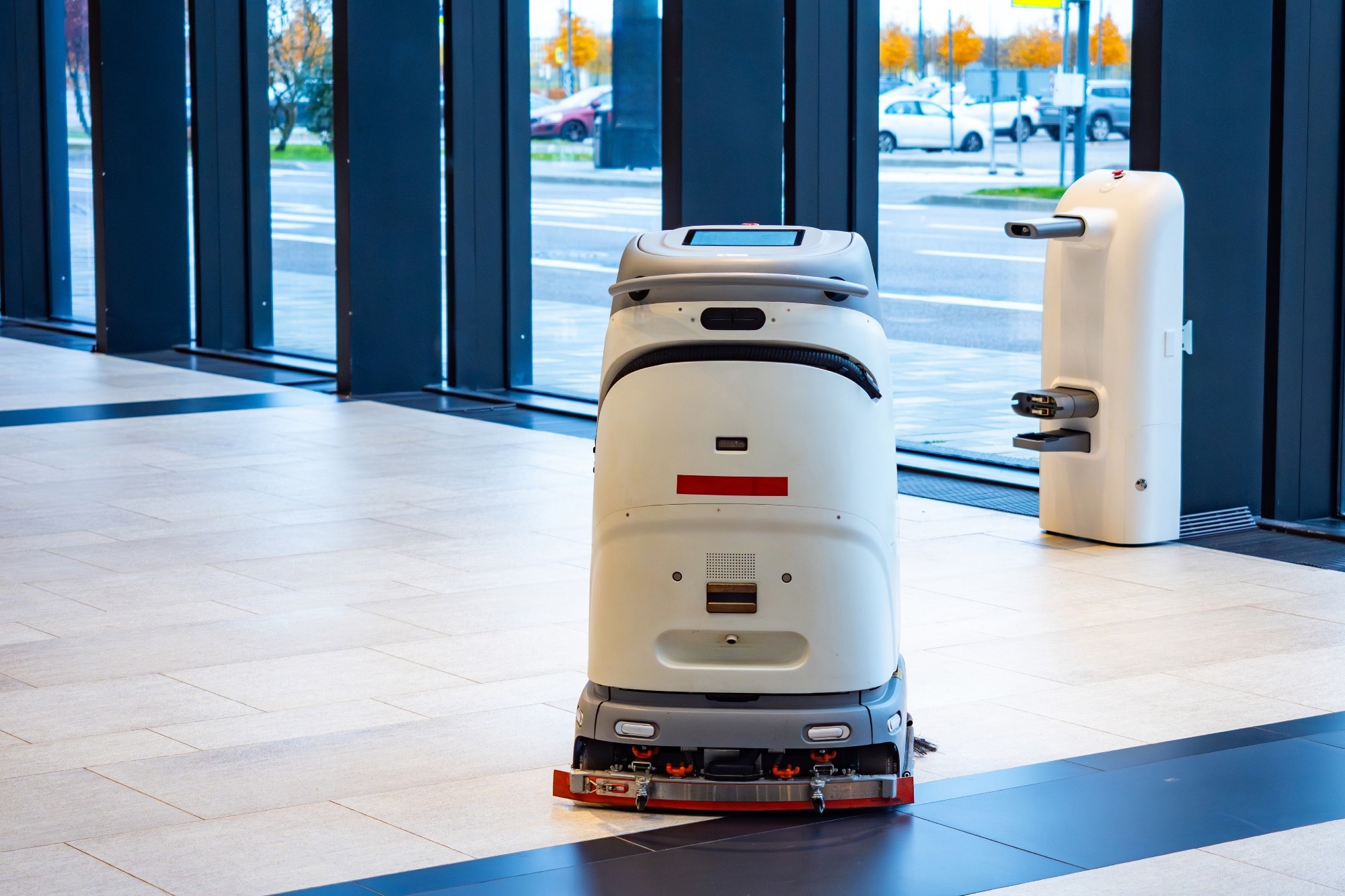
Multi-Resolution Mapping Improves Autonomous Robot Exploration Efficiency
A team of researchers has developed a groundbreaking multi-resolution exploration method aimed at improving robotic navigation in complex and unfamiliar environments. This innovative approach enhances the efficiency and adaptability of robots, enabling them to better navigate obstacles and varying terrain. The research, which was conducted in late 2023, addresses the growing need for advanced robotic systems capable of operating in unpredictable settings, such as disaster zones or remote exploration areas. By employing this new method, robots can dynamically adjust their navigation strategies based on real-time data, ultimately increasing their effectiveness in completing tasks. The findings promise to significantly advance the field of robotics, paving the way for more autonomous and resilient machines in the future.

Real‐Time Monocular 2D Occupancy Grid Mapping for Autonomous Navigation of Ground Robots
In May 2026, researchers published a significant study in the Journal of Field Robotics, focusing on advancements in robotic technology. The study, appearing in Volume 43, Issue 3, pages 1844-1860, highlights innovative methodologies for enhancing the efficiency and autonomy of field robots. Conducted by a team of experts in robotics and artificial intelligence, the research aims to address the growing demand for automation in various industries, including agriculture and disaster response. The findings reveal new algorithms that improve navigation and decision-making processes for robots operating in complex environments. This research is particularly relevant as industries increasingly seek to integrate robotic solutions to optimize operations and reduce human risk in hazardous situations. By employing advanced machine learning techniques, the team demonstrated how robots can adapt to dynamic conditions, thereby increasing their effectiveness in real-world applications. The study's implications extend beyond theoretical advancements, as it provides practical frameworks for deploying robots in challenging scenarios. As the field of robotics continues to evolve, this research contributes to the ongoing dialogue about the future of automation and its potential to revolutionize traditional practices across multiple sectors.
RESEARCH ARTICLE
Real‐Time Terrain Traversability Analysis and Mapping for Autonomous Robotics in Dynamic Environments: Fusing Appearance‐ and Geometry‐Based Approaches
In a recent study published in the Journal of Field Robotics, researchers explored advancements in robotic technologies aimed at enhancing agricultural efficiency. The study, which appears in the May 2026 issue, highlights innovative approaches to integrating robotics into farming practices to address labor shortages and improve crop yields. Conducted by a team of experts in robotics and agriculture, the research was carried out in various agricultural settings to assess the effectiveness of these technologies in real-world applications. The findings suggest that the implementation of autonomous robots can significantly streamline farming operations, reduce costs, and increase productivity. This research is particularly timely as the agricultural sector faces increasing challenges due to a declining workforce and the need for sustainable practices. The study emphasizes the potential of robotics to transform the industry, paving the way for smarter, more efficient farming solutions.
RESEARCH ARTICLE
NOAA Ship to Map Potential Critical Mineral Deposits in U.S. Waters of Pacific Ocean
In early April, the NOAA Ship Rainier will embark on a mission to map and characterize over 8,000 square nautical miles of federal waters surrounding Kingman Reef and Palmyra Atoll in the Pacific Ocean. This initiative is part of the U.S. Department of Commerce's efforts to implement the Offshore Critical Minerals Mapping Plan, which aligns with President Trump’s Executive Order 14285 aimed at unlocking America's offshore critical minerals and resources. The project underscores the government's commitment to enhancing understanding of marine resources and promoting sustainable management of these vital areas.
noaa critical mineral deposits subsea mining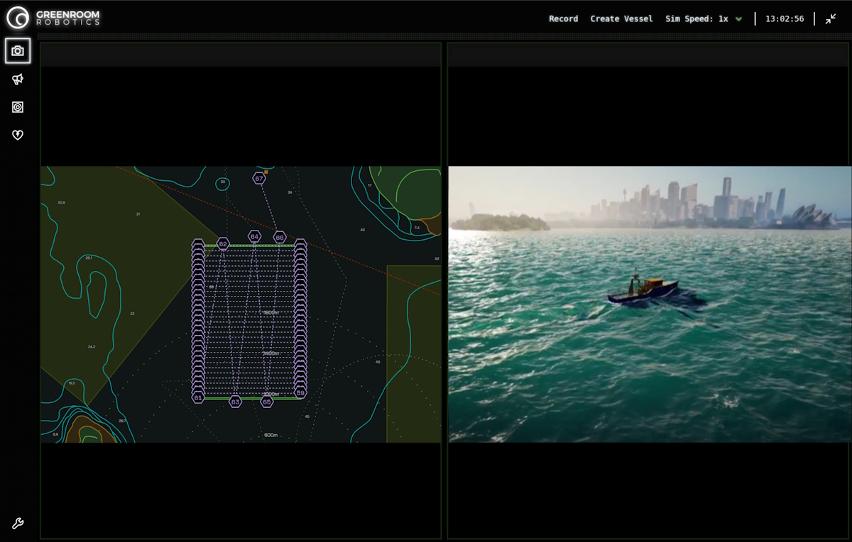
Seabed 2030 and Greenroom Robotics Announce Partnership to Support Global Ocean Mapping
The Nippon Foundation-GEBCO Seabed 2030 Project has formed a partnership with Greenroom Robotics, an Australian company specializing in artificial intelligence and autonomy for maritime operations. This collaboration aims to enhance the safety, efficiency, and environmental sustainability of maritime activities through advanced perception and autonomy software. The announcement highlights the growing importance of innovative technologies in supporting responsible maritime practices as the project continues its mission to map the world's seabed by 2030.
seabed 2030 greenroom robotics partnership global ocean mapping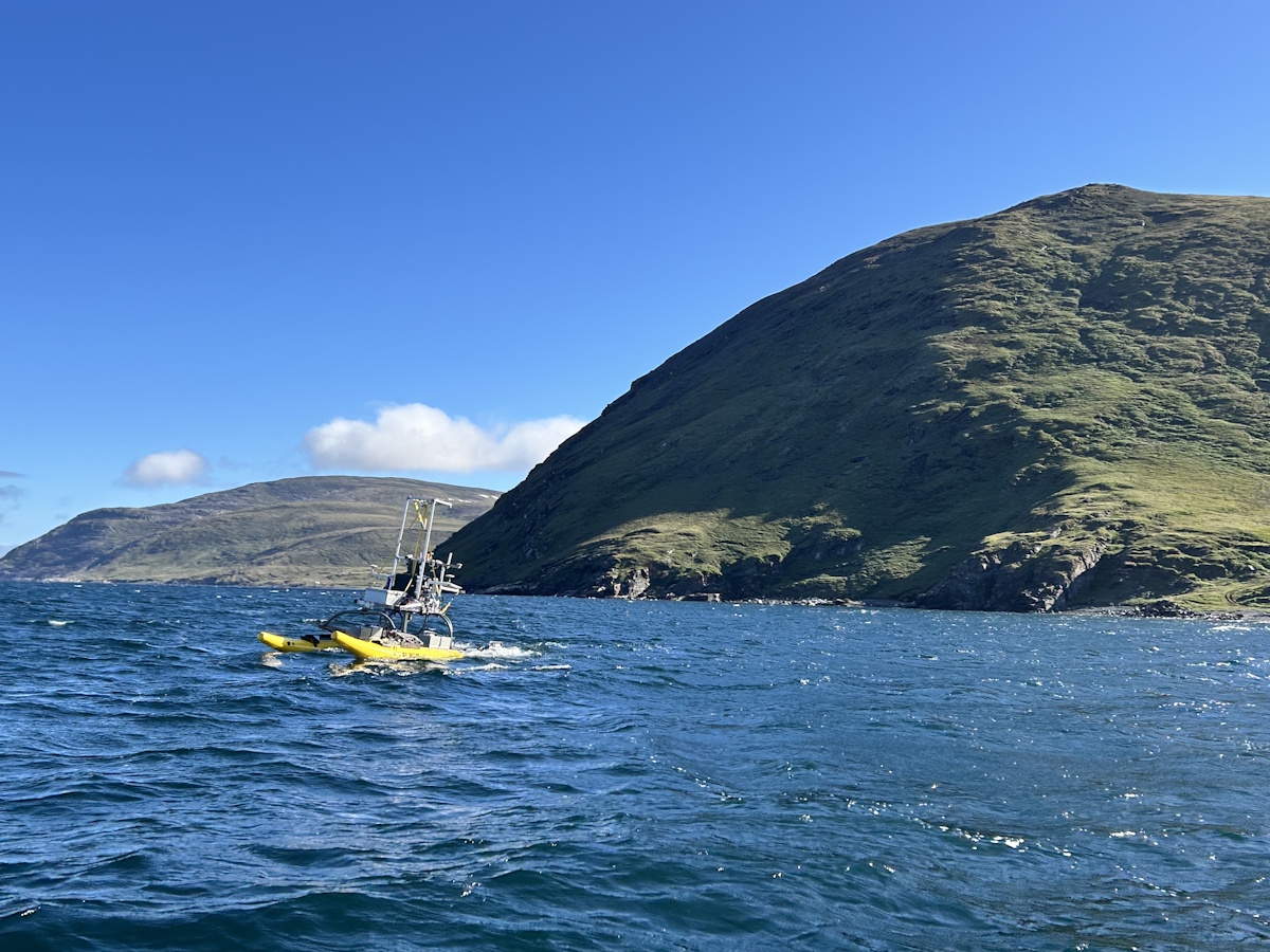
Mapping the Unmappable: Sulmara Discover and the Nunavik EAUFON-3 Project
Seaforth Geosurveys is undertaking the Nunavik EAUFON-3 Project, which aims to assess the seabed in Ungava Bay, Canada, for the installation of a fibre-optic cable. This initiative is set against the backdrop of the Arctic's harsh environment and the shallow waters that complicate traditional surveying methods. The project highlights the need for innovative approaches to overcome the unique challenges posed by the region's conditions.
arctics sulmara discover nunavik eaufon-3 project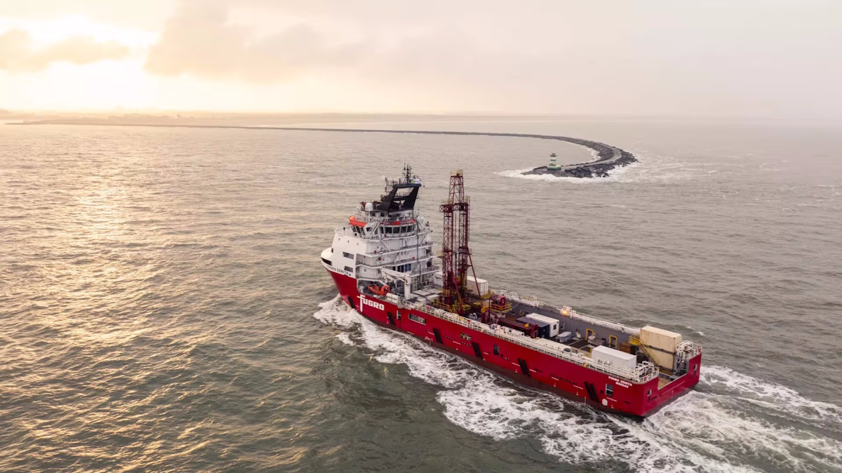
Fugro Reinforces its Role as Major Contributor to UN Ocean Decade Initiative for Seabed Mapping
Fugro has reaffirmed its commitment to the Nippon Foundation-GEBCO Seabed 2030 project, a key initiative under the United Nations Ocean Decade, during the Oceanology International event held in London. As the Ocean Decade approaches its midpoint, the company is enhancing its contribution by expanding the fleet of vessels involved in the Seabed 2030 project. Notably, Fugro's largest vessels, which are primarily engaged in geotechnical surveys, will now also participate in the collection of vital ocean-floor data, complementing the efforts of the existing geophysical fleet. This expansion aims to accelerate the mapping of the world's seabeds, supporting global efforts to better understand and protect oceanic environments.
fugro un ocean decade initiative for seabed mapping
Kongsberg Discovery launches HISAS2020 as standalone solution, setting a new standard in ultra-high-resolution underwater imaging
Kongsberg Discovery has launched the HISAS2020 synthetic aperture sonar, making one of the world’s most advanced underwater imaging technologies accessible to the market. This innovative sonar system is designed to enhance underwater exploration and mapping capabilities, providing users with high-resolution imagery that can significantly improve marine research, resource management, and environmental monitoring. The launch, which took place today, aims to meet the growing demand for sophisticated underwater imaging solutions across various sectors, including defense, oil and gas, and scientific research. By leveraging cutting-edge technology, Kongsberg Discovery seeks to empower organizations with the tools necessary for more effective underwater analysis and decision-making.
kongsberg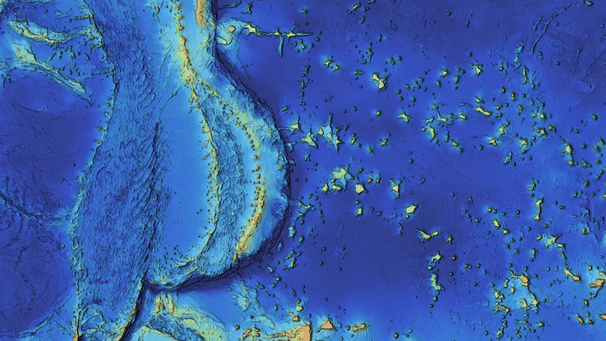
Mapping the Mariana Islands: Saildrone Partners with Woolpert to Survey Critical Maritime Region for NOAA
The Mariana Trench, home to Challenger Deep, the deepest point in the world's oceans at 10,935 meters (35,876 feet), remains one of the least explored and most geologically significant areas on Earth. This underwater marvel, located in the western Pacific Ocean, continues to intrigue scientists and researchers due to its profound depths and unique geological features. Efforts to map and study this region are crucial for understanding oceanic processes and biodiversity, as well as the effects of climate change on deep-sea ecosystems. As exploration technologies advance, researchers aim to uncover the mysteries of the trench and its surrounding islands, shedding light on the fundamental workings of our planet’s oceans.
mapping mariana islands saildrone woolpert survey noaa
3D Mobile Mapping for Digital Twins: Camera Features That Ensure Accuracy
Recent advancements in surveillance technology have transformed urban environments into rich sources of visual data, essential for creating digital twins of cities. These digital replicas rely heavily on high-quality imagery captured by cameras installed in various public spaces, including streets and buildings. However, experts warn that if the visual data collected is inadequate or flawed, the integrity and functionality of the entire digital model can be compromised. This reliance on precise imagery underscores the importance of maintaining and upgrading surveillance systems to ensure accurate representations of urban landscapes. As cities increasingly adopt these technologies, the challenge remains to balance effective data collection with privacy concerns, prompting ongoing discussions among policymakers and technology developers.
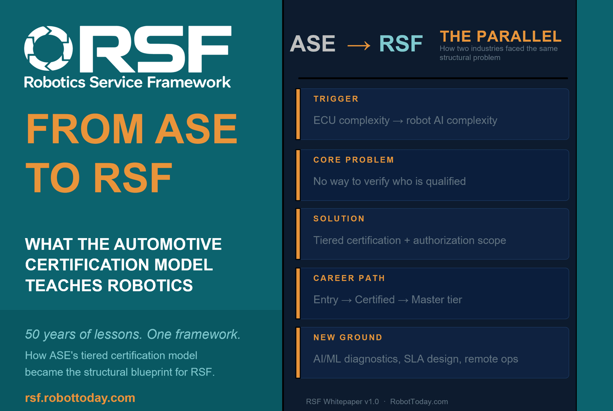
Robotics needs a service framework.
RSF defines a common language for robot service capability, lifecycle operations, certification pathways, and service-provider networks.