Industry Briefing
A single destination for timely, editor-curated robotics news from around the world.

Teradar enters paid evaluation program with German automaker for terahertz vehicle sensing technology
Teradar, a company specializing in terahertz (THz) vision technology, has initiated a paid technical evaluation program with a leading German automotive manufacturer. This collaboration aims to assess Teradar's innovative sensing technology for potential integration into advanced driver assistance systems (ADAS) and autonomous driving platforms. The evaluation will specifically target challenging scenarios where traditional sensing technologies, including cameras, radar, and lidar, may face limitations. By exploring the capabilities of THz technology, both Teradar and the automotive manufacturer seek to enhance the safety and efficiency of future automotive systems.
Components Design Engineering adas advanced driver assistance systems automation news
Robust.AI chooses Aptiv PULSE sensor for Gen 3 Carter mobile robot
Robust.AI has selected Aptiv's PULSE sensor for its third-generation Carter mobile robot, enhancing the robot's ability to navigate safely around people. This collaboration leverages Aptiv's advanced sensor fusion technology, which integrates radar and vision systems powered by artificial intelligence. The integration aims to improve the operational safety and efficiency of the Carter robot in various environments. This development marks a significant step forward in the robotics industry, as it addresses the growing need for autonomous systems to operate safely in human-populated spaces.
Autonomous Mobile Robots (AMRs) Collaborative Robots Logistics Manufacturing Mobility / Navigation News
Danish Investigation Finds No Proof Drones Caused Copenhagen Airport Shutdown
A comprehensive nine-month investigation into the temporary closure of Copenhagen Airport last September has revealed no evidence linking the disruption to drone activity. Danish police announced that their inquiry, which focused on the events surrounding the airport's shutdown on September 22, failed to substantiate claims that drones were involved. The findings highlight the necessity for improved airspace awareness rather than further speculation about drone-related incidents. This conclusion raises questions about the reliability of initial reports and emphasizes the importance of thorough investigations in aviation safety.
Anti-drone technology C-UAS Drone News Drone News Feeds Drones in the News Europe Drone Industry![[Man-ki Kim] Foster dual-use defense tech](/uploads/2026/06/2669837006758506.jpg)
[Man-ki Kim] Foster dual-use defense tech
For much of the 20th century, defense technology evolved within a tightly controlled military-industrial framework, where governments dictated needs, contractors created solutions, and civilian sectors reaped the benefits later. However, this paradigm is shifting. In the contemporary landscape, advancements in technologies such as artificial intelligence, semiconductors, robotics, batteries, cloud computing, autonomous systems, synthetic-aperture radar satellites, and commercial drones are increasingly emerging from the civilian economy. This transformation is reshaping how defense capabilities are developed and integrated, highlighting the growing interdependence between civilian innovations and military applications. As a result, the defense sector is now leveraging these civilian technologies to enhance its operational effectiveness and adaptability in a rapidly changing global environment.
All News
MQ-9 Getting Airborne Early Warning Radar Is A Huge Deal
The introduction of radar-equipped MQ-9 drones marks a significant advancement in airborne early warning capabilities, addressing an urgent need for enhanced surveillance in contemporary military operations. This development comes at a time when the demand for cost-effective and adaptable aerial monitoring solutions is critical. The MQ-9's ability to provide persistent airborne early warning is expected to improve situational awareness and response times in various operational scenarios. As military forces seek to bolster their defensive and offensive strategies, the integration of this technology is seen as a crucial step in modernizing aerial reconnaissance and ensuring readiness in an increasingly complex security environment.
Air Airborne Radar Airborne Sensors Drones News & Features Q-9
Saab unveils new Giraffe ABM Digital radar at Eurosatory 2026.
At the Eurosatory defense and security international exhibition, Saab unveiled its latest Giraffe AMB D radar system. This launch comes shortly after the Swedish Defence Materiel Administration (FMV) confirmed that it had placed an order for several units in the weeks leading up to the event. The Giraffe AMB D radar is designed to enhance surveillance and air defense capabilities, reflecting Saab's commitment to advancing military technology. The exhibition, held in Paris, serves as a significant platform for defense industry innovations, making it an ideal venue for Saab to showcase its new product and secure further interest from potential clients.
News
New radar system can detect high-speed drones nearby ports, vessels in extreme environment
A cutting-edge radar system has been developed to enhance the detection of drones operating near ports, vessels, harbors, and other critical maritime areas. This innovative technology aims to bolster maritime security by providing real-time surveillance and threat assessment capabilities. The radar is designed to identify and track drones, which have increasingly become a concern for safety and security in busy maritime environments. The system's deployment is expected to take place in the coming months, with trials set to occur at various strategic locations along coastlines. By integrating advanced detection algorithms and high-resolution imaging, the radar will enable authorities to respond swiftly to potential threats, ensuring the safety of maritime operations and protecting vital infrastructure. This initiative reflects a growing recognition of the need for enhanced security measures in response to the rising prevalence of drone activity in sensitive areas.
Innovation Military
5 Federal Drone Policies Flying Under the Radar This Summer
Several federal initiatives are set to influence the drone industry in the coming months, particularly as attention remains on Chinese drone restrictions and supply chain policies. Key developments include airspace restrictions related to the World Cup and new regulations for critical infrastructure. The long-anticipated Beyond Visual Line of Sight (BVLOS) rule is also a focal point for industry stakeholders. These initiatives, while not widely publicized, are progressing and could significantly impact the operational landscape for drones. As the summer unfolds, the drone industry is closely monitoring these changes, which may reshape regulations and operational capabilities in the near future.
DL Exclusive Drone News Drone News Feeds Drones in the News FAA Feature 1
Vantis BVLOS System Adds New Partner, FAA Waiver Across 5,000 Square Miles
Frontier Precision has received a new FAA waiver allowing it to operate any NDAA-compliant drone weighing under 55 pounds across more than 5,000 square miles of airspace managed by Vantis, North Dakota’s advanced beyond-visual-line-of-sight (BVLOS) system. This development marks Frontier Precision as the second champion operator to join the Vantis network, which aims to enhance drone operations in the region. The waiver facilitates expanded BVLOS operations within the four designated Vantis service volumes, significantly broadening the scope of drone activities in North Dakota. This partnership is expected to advance the integration of drone technology into various sectors, promoting innovation and efficiency in aerial operations.
BVLOS Drone News Drone News Feeds Long Range News Agriculture Drones
MatrixSpace Validated in U.S. Army’s Operation Jailbreak Integration Sprint
MatrixSpace, a portable radar manufacturer, has successfully integrated its technology with Anduril Lattice and IBCS-M, receiving validation from the U.S. Army during a recent exercise at Fort Carson. This achievement is part of Operation Jailbreak, the Army's largest initiative aimed at incorporating emerging technologies into command-and-control systems. The validation places MatrixSpace among 55 companies participating in this significant interoperability effort, showcasing its sensor capabilities within the Anduril framework. The integration is expected to enhance the Army's operational effectiveness by streamlining communication and coordination among various technological platforms.
Defense Drone News Drone News Feeds Military News air defense
Boeing validates stealth capability of MQ-28 Ghost Bat
Boeing has confirmed the stealth capabilities of its MQ-28 collaborative combat aircraft (CCA) after conducting radar cross-section (RCS) tests aimed at assessing its survivability and detection risks. The tests, which are part of Boeing's ongoing efforts to enhance the aircraft's operational effectiveness, demonstrate the company's commitment to developing advanced military technology. The results indicate that the MQ-28 can effectively minimize its radar signature, thereby increasing its chances of evading enemy detection. This validation comes as military forces worldwide seek to integrate more advanced, stealthy unmanned systems into their operations, reflecting a growing emphasis on survivability in modern combat scenarios.
News
Japan’s IHI begin to benefit from ICEYE SAR imagery
IHI, a prominent player in Japan's aerospace industry, has successfully integrated two operational ICEYE synthetic aperture radar (SAR) satellites into its operations, with plans to deploy two additional satellites in the near future. This advancement marks a significant step for IHI, enhancing its capabilities in satellite technology and data acquisition. The deployment of these satellites is expected to bolster IHI's position in the aerospace sector, allowing for improved monitoring and analysis of various environmental and industrial applications. The initiative reflects IHI's commitment to advancing its technological offerings and responding to the growing demand for satellite-based data solutions.
News
Radar tech could help scale police drone programs faster
As police departments throughout the United States enhance their drone programs, they are facing a growing challenge related to congested low-altitude airspace. The proliferation of both authorized emergency-response drones and unauthorized aircraft operating near critical sites has heightened the need for law enforcement agencies to improve their situational awareness of aerial activities. This development comes as agencies seek to leverage drone technology for various operational purposes, including surveillance and emergency response, while navigating the complexities of airspace management. The increasing demand for drone usage underscores the urgency for effective solutions to monitor and regulate the crowded skies, ensuring safety and security in urban environments.
News
The Strategic Advantage of Rapid Deployment Weather Tracking for Critical Sectors
Field operations across various sectors, including construction and emergency response, are increasingly challenged by unpredictable weather patterns that can compromise safety and hinder progress. As traditional weather forecasts often fail to accurately predict localized storms, the reliance on fixed-location radar stations has become problematic due to their frequent blind spots. This situation underscores the urgent need for more advanced weather monitoring solutions to enhance operational safety and efficiency. By addressing these gaps in forecasting, organizations can better prepare for adverse weather conditions, ultimately improving outcomes in critical field operations.
Communications Infrastructure atmospheric monitoring automation news autonomous systems aviation safety
US Air Force sends ULTRA Turbo drone with multi-day endurance to Middle East
The U.S. Air Force is set to deploy an enhanced version of its ULTRA surveillance glider, designed to improve reconnaissance capabilities. This advanced system, which features upgraded technology for better data collection and analysis, is expected to be operational in the coming months. The deployment aims to bolster national security and enhance situational awareness in various operational theaters. By utilizing the glider's unique design, which allows for extended flight durations and reduced radar visibility, the Air Force seeks to gather critical intelligence while minimizing risks to personnel and assets. The initiative reflects a broader strategy to modernize military surveillance methods in response to evolving global threats.
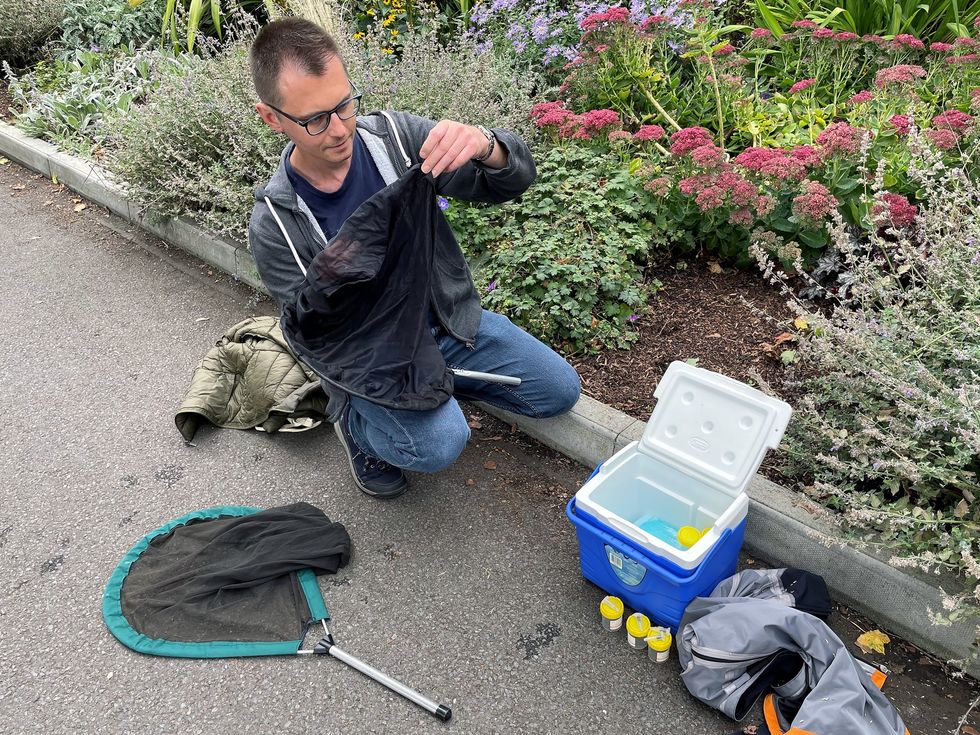
Radar Can Tell the Difference Between Insect Species
Researchers at the Technological University of Denmark have developed a groundbreaking radar system aimed at monitoring pollinators, such as bees and wasps, in a cost-effective and non-invasive manner. Traditional methods of tracking these vital insects have been labor-intensive and often harmful, as they typically require capturing and killing specimens for identification. The new approach, detailed in a study published on April 28 in the journal PNAS Nexus, leverages millimeter-wave radar technology to analyze micro-Doppler signatures generated by insect wingbeats. The team, led by associate professor Adam Narbudowicz, trained a machine learning model using radar data from five species of pollinators captured on the campus of Trinity College Dublin. By focusing on the unique radar reflections produced by the insects, the researchers achieved an impressive 85 percent accuracy in species classification and 96 percent accuracy in distinguishing between bee and wasp species. The accuracy improved with the duration of time the insects remained in the radar beam, suggesting potential for further refinement. This innovative radar system not only promises to enhance the monitoring of pollinators but could also be adapted to track pests and invasive species. The researchers aim to create a portable version of the technology and establish a global database of insect radar signatures, which could include environmental factors to better understand how conditions affect pollinator behavior. This advancement could ultimately contribute to more effective conservation efforts and agricultural practices.
Radar Insects Machine-learning
Uber is deploying its own self-driving cars again, just not as robotaxis
Uber has reintroduced its autonomous vehicles to the streets as part of its new Autonomous Vehicle (AV) Lab initiative. This project aims to gather data for its numerous robotaxi partners. The vehicles will be equipped with standard self-driving technology, including cameras, lidar, and radar. However, these cars will not be functioning as fully operational robotaxis during this phase. The decision to restart testing comes as part of Uber's strategy to enhance its data collection capabilities and improve the performance of its autonomous driving systems. The initiative is expected to contribute to the development of safer and more efficient self-driving technology in the future.
Autonomous Cars News Ride-sharing Transportation Uber
Enabling Autonomous Machines: Advancing 3D Sensor Fusion With Au-Zone
A new technological advancement in autonomous systems has been announced, emphasizing the integration of radar and vision with edge AI processing into a single unit. This innovative approach aims to enhance the speed, reliability, and robustness of next-generation autonomous solutions. The development is crucial for meeting the increasing demands for advanced autonomy in various applications. The system is designed to operate efficiently, leveraging cutting-edge technology to ensure optimal performance in real-time scenarios. This breakthrough is expected to significantly impact industries reliant on autonomous technologies, paving the way for more sophisticated and dependable systems in the near future.
NATO integrates radars, kinetic interceptors to hit target; boost counter-drone lethality
NATO troops have been observed enhancing their counter-drone capabilities through recent training exercises. The soldiers were seen engaging in drills aimed at improving their skills in detecting and neutralizing unmanned aerial vehicles. This initiative comes amid rising concerns over the increasing use of drones in modern warfare and the potential threats they pose to military operations and security. The training sessions took place at various military installations across Europe, where troops utilized advanced technology and tactics to prepare for potential drone-related challenges. By bolstering their counter-drone strategies, NATO aims to ensure the safety and effectiveness of its forces in the face of evolving threats.
New electronic warfare system can locate enemy drones, radars without sending signals
Leonardo has unveiled a cutting-edge electronic warfare and signals intelligence system designed to enhance the capabilities of military troops. This innovative technology was introduced during a recent defense exhibition held in London, showcasing the company's commitment to advancing military operations. The system aims to provide armed forces with improved situational awareness and the ability to counteract potential threats in real-time. By integrating advanced data processing and analysis features, the new system allows for more effective communication and coordination among units on the battlefield. Leonardo's development of this technology reflects the growing need for enhanced defense solutions in an increasingly complex global security environment.

ICEYE delivers Poland’s radar satellite system in under 12 months
ICEYE has successfully delivered the MikroSAR radar satellite reconnaissance system to the Polish Armed Forces, achieving this milestone in under a year following the contract signing. This swift deployment underscores ICEYE's commitment to enhancing Poland's defense capabilities through advanced satellite technology. The MikroSAR system is designed to provide critical reconnaissance data, enabling improved situational awareness and operational effectiveness for military operations. The delivery marks a significant step in strengthening Poland's defense infrastructure and showcases ICEYE's efficiency in fulfilling defense contracts.
News
Robin Radar Names Homeland Security and Defense Leads for US Expansion
Robin Radar Systems, a Dutch company specializing in drone-detection radar, has announced a significant expansion in the United States to meet the growing demand for homeland security solutions. On May 18, 2026, the company revealed the appointment of senior sales leadership and the establishment of a larger headquarters in Virginia. This strategic move aims to enhance their operational capabilities and better serve the national security sector as concerns over drone-related threats continue to rise. By bolstering its presence in the U.S. market, Robin Radar Systems seeks to strengthen its position in the defense industry and address the increasing need for advanced counter-drone technologies.
Anti-drone technology C-UAS defense Drone News Drone News Feeds Military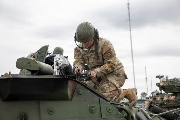
MatrixSpace Brings Portable Counter-Drone Radar to Lithuanian Exercise
MatrixSpace, a Massachusetts-based company, is enhancing low-altitude airspace awareness for M-SHORAD units in Pabradė, Lithuania, by deploying its portable AI-powered radar system. This initiative is part of the U.S. Army’s Flytrap 5.0 counter-drone exercise, taking place from May 1 to May 15, 2026. The announcement of MatrixSpace's involvement was made on May 12, following their recent success in the xTechCounter Strike competition during the previous Flytrap 4.5 exercise. The deployment aims to bolster the Army's capabilities in counter-drone operations, reflecting the growing need for advanced technologies in modern military exercises.
Defense defense Drone News Drone News Feeds Military News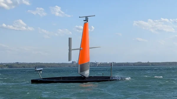
Saildrone Deploys 16 Voyager USVs for Coast Guard Great Lakes Mission
Saildrone, an autonomous maritime company based in Alameda, California, has announced the deployment of 16 Voyager unmanned surface vehicles (USVs) to enhance surveillance capabilities for the US Coast Guard. This initiative, which is part of a $15.5 million contract, aims to support Coast Guard missions across the Great Lakes and the Northeast. The deployment was officially announced on May 11, 2026, marking a significant step in the integration of advanced technology into maritime operations. The use of these unmanned vehicles is intended to improve monitoring and response efforts in these vital waterways, reflecting the Coast Guard's commitment to maintaining safety and security in the region.
Drone News Drone News Feeds News ocean safety and security seadrones
From Pixels to Production: Texas Instruments and NVIDIA Partner to Harden Humanoid Safety
Texas Instruments has announced the integration of its mmWave radar technology with NVIDIA's Jetson Thor platform, aiming to enhance robotic safety in real-world applications. This collaboration seeks to address the critical "last mile" challenge in AI deployment, where simulated environments often differ from actual operational conditions. By combining advanced radar capabilities with powerful AI processing, the partnership intends to improve the reliability and effectiveness of robotic systems in various settings. The initiative reflects a growing trend in the tech industry to bridge the gap between theoretical AI models and practical, safe implementations in everyday environments.
NVIDIA nvidia-gtc Market Texas Instruments
China’s AgiBot leads global humanoid robot shipments in 2025, Omdia says
AgiBot, a Chinese manufacturer of humanoid robots, has emerged as the global leader in shipment volume for 2025, delivering 5,168 units and capturing 39% of the worldwide market share. This information comes from a recent report by market research firm Omdia, which highlighted the rapid growth phase of the global humanoid robot market. The report, titled General-Purpose Embodied Robotics Market Radar, indicates a significant surge in demand and production within this sector, reflecting advancements in technology and increasing applications for humanoid robots across various industries.
News Feed
DJI launches FC100 delivery drone with 80kg payload, starting at $12,500
Chinese drone manufacturer DJI introduced its latest flagship civilian delivery drone, the FC100, on Monday. Priced starting at RMB 89,999 (approximately $12,500), the FC100 is designed to enhance delivery capabilities with a maximum payload capacity of 80 kilograms. The drone boasts an impressive flight range, capable of traveling up to 6 kilometers on a single battery and extending to 12 kilometers when equipped with dual batteries. Incorporating advanced technology, the FC100 is equipped with LiDAR (Light Detection and Ranging) and millimeter-wave radar, which enhance its navigation and obstacle avoidance capabilities. This launch reflects DJI's commitment to advancing drone technology and meeting the growing demand for efficient delivery solutions in various sectors. The introduction of the FC100 is expected to significantly impact the logistics and delivery industry, providing businesses with a reliable tool for transporting goods quickly and efficiently.
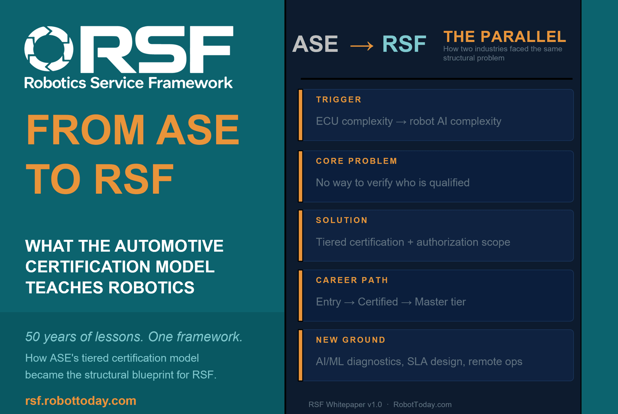
News FeedRobotics needs a service framework.
RSF defines a common language for robot service capability, lifecycle operations, certification pathways, and service-provider networks.