Industry Briefing
A single destination for timely, editor-curated robotics news from around the world.
Coast Guard, Saildrone team up in northern waters to boost border security, surveillance
The Voyager, a state-of-the-art surveillance vessel, has been designed to carry out continuous coastal monitoring and nearshore mapping operations. This advanced ship can remain deployed at sea for approximately 100 days, enhancing its capability to gather critical data over extended periods. The implementation of the Voyager is expected to significantly improve maritime security and environmental monitoring efforts, providing valuable insights into coastal ecosystems and aiding in the management of marine resources. With its advanced technology and extended operational range, the Voyager represents a significant advancement in maritime surveillance capabilities.
Naval Warfare border security coast guard Drones Navy Saildrone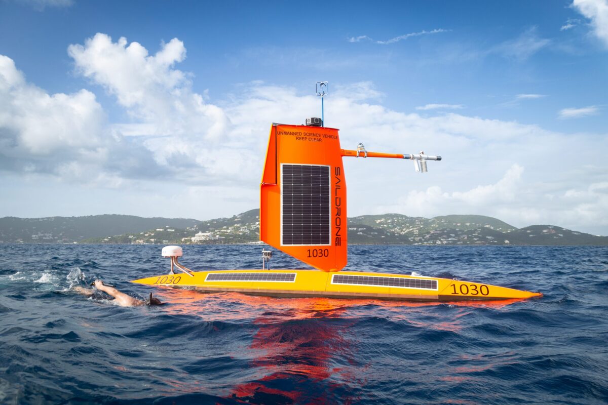
NOAA Sends Autonomous Surface Vehicles Into Hurricanes to Study Rapid Intensification
Saildrone, in collaboration with the National Oceanic and Atmospheric Administration (NOAA), has announced the deployment of 10 unmanned surface vehicles (USVs) during the 2026 hurricane season. This initiative aims to enhance hurricane forecasting and improve models for rapid intensification across the Atlantic basin. The partnership reflects a commitment to advancing storm research and understanding the dynamics of hurricanes, which is crucial for better preparedness and response strategies. By utilizing autonomous technology, the mission seeks to gather critical data that can lead to more accurate predictions and ultimately save lives during severe weather events.
Drone News Drone News Feeds News Research Weather Atlantic hurricane season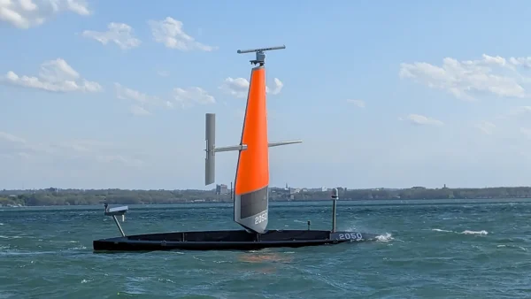
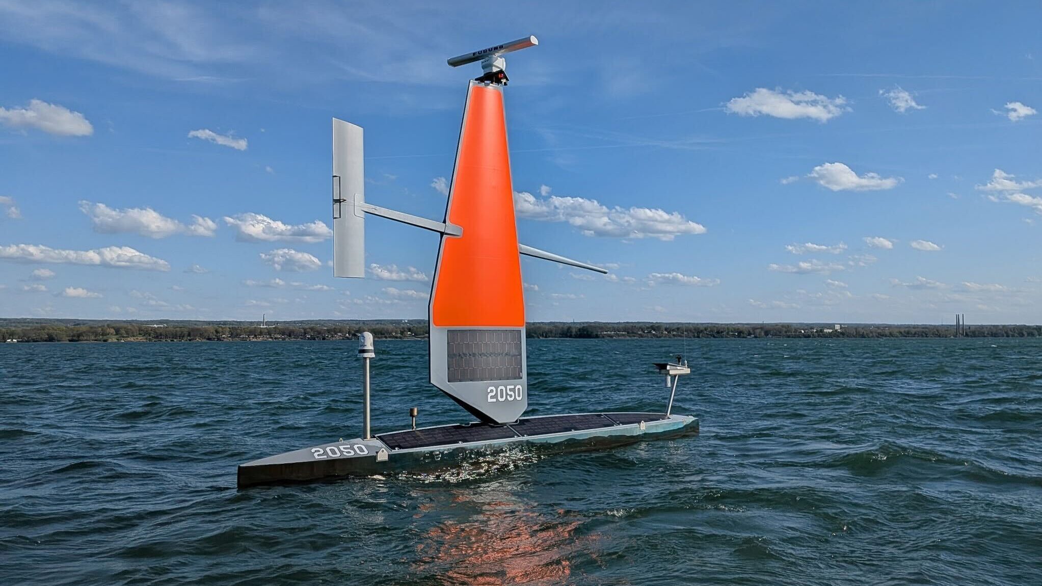
Saildrone Deploys 16 Voyager USVs for Coast Guard Great Lakes Mission
Saildrone, an autonomous maritime company based in Alameda, California, has announced the deployment of 16 Voyager unmanned surface vehicles (USVs) to enhance surveillance capabilities for the US Coast Guard. This initiative, which is part of a $15.5 million contract, aims to support Coast Guard missions across the Great Lakes and the Northeast. The deployment was officially announced on May 11, 2026, marking a significant step in the integration of advanced technology into maritime operations. The use of these unmanned vehicles is intended to improve monitoring and response efforts in these vital waterways, reflecting the Coast Guard's commitment to maintaining safety and security in the region.
Drone News Drone News Feeds News ocean safety and security seadrones
Saildrone Supports Coast Guard Missions in the Great Lakes and Northeast
The U.S. Coast Guard is enhancing its efforts to monitor the extensive northern maritime approaches, which encompass thousands of miles of coastline, busy waterways, and vital fishing grounds from the Great Lakes to the North Atlantic. This initiative, aimed at detecting suspicious vessel activity and securing the U.S. border, is critical for maintaining economic prosperity and protecting domestic fisheries. The Coast Guard faces challenges in ensuring consistent visibility due to unpredictable weather, seasonal variations, and the vastness of the region. Traditional patrols struggle with issues such as crew endurance, maintenance needs, and the distances involved. As a result, the Coast Guard is exploring innovative strategies to improve surveillance and response capabilities in these challenging maritime environments.
saildrone contract award us coast guard maritime domain awareness (mda)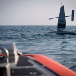
US Coast Guard deploys autonomous Saildrones to patrol 90,000-square-mile lakes
The U.S. Coast Guard is set to deploy autonomous surface drones across the Great Lakes starting in May. This initiative aims to enhance maritime safety and environmental monitoring in the region. The deployment comes in response to increasing concerns over navigation hazards and the need for improved surveillance of the lakes' ecosystems. By utilizing advanced drone technology, the Coast Guard intends to efficiently gather data and monitor conditions, thereby bolstering their operational capabilities. The drones will operate in various locations across the Great Lakes, providing real-time information that can aid in search and rescue missions, as well as environmental protection efforts. This strategic move reflects the Coast Guard's commitment to leveraging innovative solutions to address contemporary challenges in maritime operations.
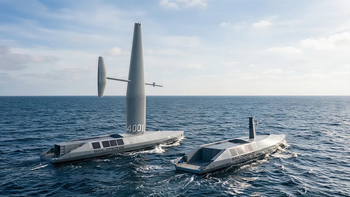
Introducing Saildrone Spectre: Next-generation USV for Anti-submarine Warfare and VLS Strike
The US Navy is grappling with significant challenges in upholding maritime dominance amid escalating global conflicts. As tensions rise in various regions, adversaries are increasingly focusing on strategically vital waterways and essential undersea infrastructure. The Navy's traditional reliance on episodic patrols by manned warships and capital assets proves inadequate for the continuous presence required to safeguard these expansive maritime areas. This situation underscores the urgent need for a more sustainable and effective operational strategy to address the evolving threats in the maritime domain.
saildrone spectre usv anti-submarine warfare (asw) vls strike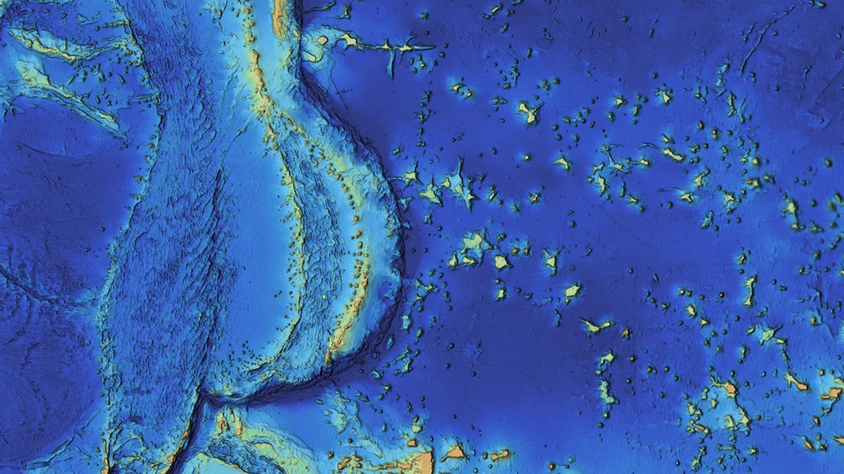
Mapping the Mariana Islands: Saildrone Partners with Woolpert to Survey Critical Maritime Region for NOAA
The Mariana Trench, home to Challenger Deep, the deepest point in the world's oceans at 10,935 meters (35,876 feet), remains one of the least explored and most geologically significant areas on Earth. This underwater marvel, located in the western Pacific Ocean, continues to intrigue scientists and researchers due to its profound depths and unique geological features. Efforts to map and study this region are crucial for understanding oceanic processes and biodiversity, as well as the effects of climate change on deep-sea ecosystems. As exploration technologies advance, researchers aim to uncover the mysteries of the trench and its surrounding islands, shedding light on the fundamental workings of our planet’s oceans.
mapping mariana islands saildrone woolpert survey noaa
Saildrone Completes Pioneering Mapping Mission of Cayman Islands’ EEZ
Saildrone, a leader in autonomous deep-water mapping, has successfully completed a mission to map the exclusive economic zone of the Cayman Islands. Over approximately 300 days, the company utilized its Saildrone Surveyor uncrewed surface vehicle to survey around 90,000 square kilometers of seabed, reaching depths of up to 7,000 meters. The mission included over 900 sound-velocity profile casts to ensure the accuracy of the bathymetric data collected. A key focus of the survey was on four significant fishing banks—60 Mile Bank, Lawfords Bank, Pickle Bank, and 12 Mile Bank—which are vital for biodiversity and support local fisheries, tourism, and recreational activities. These areas also serve as indicators of the overall health of the Cayman Islands' marine ecosystem. The successful completion of this mapping mission is expected to enhance understanding and management of the region's marine resources.
saildrone pioneering mapping mission
Bringing Firepower to the Fleet: Lockheed Martin Invests $50M in Saildrone to Advance Unmanned Surface Vehicle Capabilities for US Navy
Lockheed Martin has announced a significant investment of $50 million in Saildrone, Inc., aimed at enhancing the capabilities of unmanned surface vehicles (USVs). This partnership, revealed today, seeks to integrate advanced defense technology with Saildrone's proven USV systems, positioning them for military applications. The collaboration is expected to accelerate the development of these vehicles, equipping them with cutting-edge technology for all-domain defense operations. The investment underscores Lockheed Martin's commitment to advancing defense solutions and reflects the growing importance of innovative technologies in military strategy.
lockheed martin investment saildrone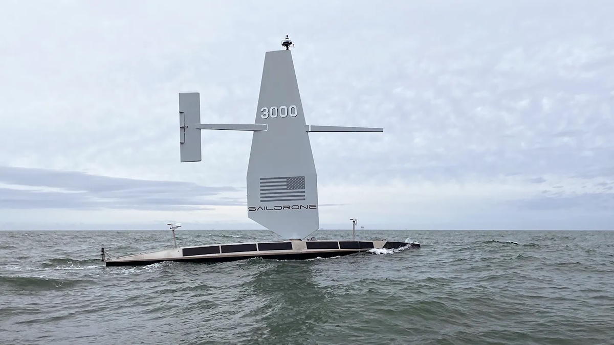
Revolutionizing Deep-water Cable Route Surveys with Autonomous Platforms
Saildrone, in collaboration with Meta, has achieved a significant milestone by completing the first autonomous deep-water cable route survey in the North Atlantic. This groundbreaking project, which took place recently, sets a new standard for offshore mapping techniques. The initiative aims to enhance the efficiency and accuracy of underwater surveys, crucial for the development of future telecommunications infrastructure. By utilizing advanced autonomous technology, Saildrone's innovative approach allows for comprehensive data collection in challenging marine environments, paving the way for safer and more reliable underwater cable installations.
deep-water cable route surveys autonomous platforms
Saildrone Announces Denmark Expansion
Saildrone has announced the launch of its first European subsidiary, Saildrone Denmark, located in Copenhagen. This expansion marks a significant milestone in the company's mission to enhance persistent maritime domain awareness, which they regard as essential for global maritime operations. By establishing a presence in Europe, Saildrone aims to strengthen its capabilities and services in the region, addressing the growing demand for advanced maritime monitoring solutions. The launch reflects the company's commitment to leveraging innovative technology for improved maritime safety and environmental protection.
saildrone expansion
Saildrone and Thales Australia Demonstrate Game-changing Capability for Autonomous Anti-Submarine Warfare
Saildrone, a leader in maritime autonomy, has partnered with Thales Australia to successfully integrate the BlueSentry thin-line towed array with the Saildrone Surveyor, resulting in a pioneering system designed for autonomous long-endurance undersea maritime domain awareness (MDA). This innovative project, backed by funding from the Office of Naval Research (ONR), represents a significant advancement in the field of persistent, real-time undersea surveillance. The collaboration aims to enhance the capabilities of maritime operations by providing continuous monitoring of underwater environments, thereby improving security and situational awareness in naval operations. The demonstration highlights the potential for autonomous systems to revolutionize maritime surveillance and response strategies.
saildrone thales australia autonomous anti-submarine warfare (asw)
Saildrone and Palantir Announce Strategic Partnership to Advance AI-Powered Maritime Intelligence
As over 70% of the Earth's surface is covered by ocean, illegal activities often go undetected due to a lack of surveillance by U.S. or allied forces. Multi-mission naval assets are currently stretched thin, balancing high-stakes operations with the need for extensive open-water patrols. This situation has prompted the U.S. and its allies to seek advanced technology solutions to enhance their surveillance capabilities. The urgency for these innovations is driven by the need to optimize limited resources, sharpen strategic focus, and stay ahead of adversaries in maritime security efforts.
saildrone palantir strategic partnership ai maritime intelligenceRobotics needs a service framework.
RSF defines a common language for robot service capability, lifecycle operations, certification pathways, and service-provider networks.